IMAGES TAKEN NEAR TO
Elemore Close, NEWCASTLE UPON TYNE, NE13 9BW
Introduction
This page details the photographs taken nearby to Elemore Close, NE13 9BW by members of the Geograph project.
The Geograph project started in 2005 with the aim of publishing, organising and preserving representative images for every square kilometre of Great Britain, Ireland and the Isle of Man.

There are currently over 7.5m images from over14,400 individuals and you can help contribute to the project by visiting https://www.geograph.org.uk
Image Map (Loading...)


Getting Data...Please wait
Leaflet Map data © OpenStreetMap
Images are licensed for reuse under creativecommons.org/licenses/by-sa/2.0
Notes
- Clicking on the map will re-center to the selected point.
- The higher the marker number, the further away the image location is from the centre of the postcode.
Image Listing (17 Images Found)
Images are licensed for reuse under creativecommons.org/licenses/by-sa/2.0
Image
Details
Distance
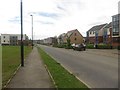
1
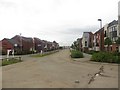
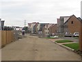
Roseden Way, Brunton Grange, Newcastle Great Park
Part of the Brunton Grange estate which itself forms part of the Newcastle Great Park development area. This part of the development is being built by Taylor Wimpey, the other developer involved in Great Park is Persimmon Homes.
Image: © Graham Robson
Taken: 10 Jul 2016
0.08 miles
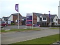
2
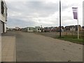
Construction site, Newcastle Great Park
A construction area where a new phase of the Brunton Grange estate is being constructed. The master plan for Great Park suggests this will be the "town centre" of the new residential area and include shops and community facilities.
Image: © Graham Robson
Taken: 10 Jul 2016
0.11 miles
3
Children's play area by Merlin Chase
Part of the Great Park development.
Image: © Oliver Dixon
Taken: 2 Sep 2019
0.11 miles
4
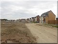
New houses, Newcastle Great Park
Newly developed houses adjacent to a space which is currently being developed on Newcastle Great Park.
Image: © Graham Robson
Taken: 10 Jul 2016
0.11 miles
5
New houses at Newcastle Great Park
A new phase of the Brunton Grange estate is being finished, extending the Newcastle Great Park development.
Image: © Graham Robson
Taken: 10 Jul 2016
0.14 miles
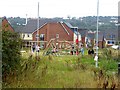
6
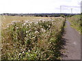
Farm Track
Looking South along a farm track near West Brunton Farm towards the outskirts of Newcastle.
Image: © Chris Bell
Taken: 29 Aug 2005
0.15 miles
7
Brunton West
One of a number of simultaneous developments by various builders in the Great Park area. Not to be confused with West Brunton, the original hamlet some 500 metres to the north-west.
Image: © Oliver Dixon
Taken: 2 Sep 2019
0.15 miles
8
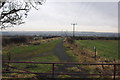
Public Footpath
Running from Brunton Lane to Fawdon Lane.
Image: © peter maddison
Taken: 12 Jan 2011
0.16 miles
9
Waggonway Drive, Brunton Grange, Newcastle Great Park
A modern development of houses forming one of the estates of the Newcastle Great Park development area.
Image: © Graham Robson
Taken: 10 Jul 2016
0.17 miles
10
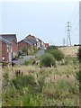
Power lines and houses on Osprey Walk
Part of the Great Park development.
Image: © Oliver Dixon
Taken: 2 Sep 2019
0.17 miles