IMAGES TAKEN NEAR TO
Broadfield Meadows, NEWCASTLE UPON TYNE, NE13 8BD
Introduction
This page details the photographs taken nearby to Broadfield Meadows, NE13 8BD by members of the Geograph project.
The Geograph project started in 2005 with the aim of publishing, organising and preserving representative images for every square kilometre of Great Britain, Ireland and the Isle of Man.

There are currently over 7.5m images from over14,400 individuals and you can help contribute to the project by visiting https://www.geograph.org.uk
Image Map (Loading...)


Getting Data...Please wait
Leaflet Map data © OpenStreetMap
Images are licensed for reuse under creativecommons.org/licenses/by-sa/2.0
Notes
- Clicking on the map will re-center to the selected point.
- The higher the marker number, the further away the image location is from the centre of the postcode.
Image Listing (49 Images Found)
Images are licensed for reuse under creativecommons.org/licenses/by-sa/2.0
Image
Details
Distance
1
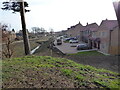
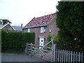
Kenton Bank Hall
View of the northern end of Kenton Bank Hall estate looking towards Kenton Bank Foot. The image is taken from the old pit heap opposite Bullock Steads which can be seen on the left of the image.
Image: © Phil Thirkell
Taken: 15 Feb 2023
0.05 miles
4
Kenton Bank Hall
The northern end of the Kenton Bank Hall estate looking towards the old pit heap opposite Bullock Steads.
Image: © Phil Thirkell
Taken: 15 Feb 2023
0.06 miles
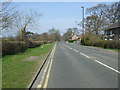
5
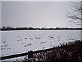
Snow-laden field near Kenton Bankfoot
This picture of a snow-laden field near Kenton Bankfoot was taken from the B6918 road (to Woolsington) looking in a westerly direction towards the A696(T) road and Low Newbiggen Farm. Just beyond the trees, the power gantries for the Tyne and Wear Metro system can be seen and, on the horizon, the run of pylons heading towards Woolsington is also visible.
Image: © Philip Barker
Taken: 2 Jan 2010
0.06 miles
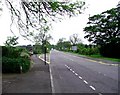
7
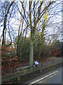
Commemorative tree at Bullock Steads
Commemorative tree planted by Professor Gilbert Smith, Vice-Chancellor of the University of Northumbria at Newcastle, to commemorate 125 years of English Rugby Union, 5th February 1997.
Update 2023: in the process of building the new clubhouse, the tree and plaque seem to have been removed.
Image: © Phil Thirkell
Taken: 1 Feb 2021
0.09 miles
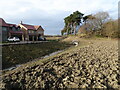
8
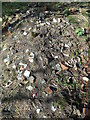
Domestic waste
The spoil heap has been used in the past as a tip for domestic waste consisting of old broken crockery, bottles, etc.
Image: © Phil Thirkell
Taken: 25 Mar 2019
0.09 miles
9

Commemorative plaque at Bullock Steads
Image: © Phil Thirkell
Taken: 1 Feb 2021
0.09 miles
10
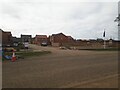
Housing development, Kenton Bank Foot
A new housing development by Taylor Wimpey on the southern side of Ponteland Road on the edge of Kenton Bank Foot.
Image: © Graham Robson
Taken: 21 Mar 2021
0.10 miles