IMAGES TAKEN NEAR TO
Elm Street, NEWCASTLE UPON TYNE, NE13 6HQ
Introduction
This page details the photographs taken nearby to Elm Street, NE13 6HQ by members of the Geograph project.
The Geograph project started in 2005 with the aim of publishing, organising and preserving representative images for every square kilometre of Great Britain, Ireland and the Isle of Man.

There are currently over 7.5m images from over14,400 individuals and you can help contribute to the project by visiting https://www.geograph.org.uk
Image Map
Images are licensed for reuse under creativecommons.org/licenses/by-sa/2.0
Notes
- Clicking on the map will re-center to the selected point.
- The higher the marker number, the further away the image location is from the centre of the postcode.
Image Listing (14 Images Found)
Images are licensed for reuse under creativecommons.org/licenses/by-sa/2.0
Image
Details
Distance
3
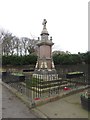
Seaton Burn War Memorial
The War Memorial on Front Street in Seaton Burn which commemorates the village's residents killed in conflict.
Image: © Graham Robson
Taken: 22 Jan 2017
0.15 miles
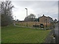
4
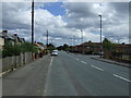
Bridge Street, Seaton Burn
Looking south along Bridge Street in Seaton Burn.
Image: © Graham Robson
Taken: 22 Jan 2017
0.16 miles
5
Former recycling point, Dudley Lane
An old sign marks a place where recycling bins once stood on Dudley Lane.
Image: © Graham Robson
Taken: 8 Oct 2017
0.16 miles
6
Bridge on the former Seaton Burn Waggonway
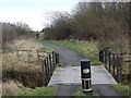
The Seaton Burn waggonway was one of many http://www.tynelives.org.uk/stephenson/wagmap2.htm linking former coalmines in North Tyneside with the coal staithes on the Tyne. This view is taken near the northern end of the waggonway, looking south, where it crosses the Seaton Burn itself. Along with many other lengths of waggonway, this section has been converted into a cycle path in recent years and forms part of National Cycle Network, Regional Route 10 (the Reivers Cycle Route) http://www.cycle-n-sleep.co.uk/rinfo/map%20reivers.htm which links Tynemouth with Whitehaven via Kielder Forest and Carlisle. The uprights at the end of the railings have been fabricated from old gas bottles.
Image: © Oliver Dixon
Taken: 23 Feb 2012
0.17 miles
7
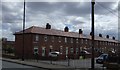
The Moor House pub, Seaton Burn
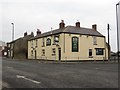
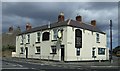
The Moor House pub is located on the corner of Front Street and Dudley Lane, Seaton Burn.
Image: © Graham Robson
Taken: 22 Jan 2017
0.17 miles
9
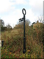
Signpost, Seaton Burn Waggonway, Seaton Burn
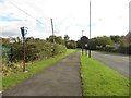
This signpost points the way to Ponteland along the route of the Reivers Way, a brace of waymarked bi-directional coast to coast cycle routes between the North and Irish Seas. There are two types of routes, an off-road route and an on-road route. At this point, the route follows the course of the old Seaton Burn Waggonway.
Image: © Geoff Holland
Taken: 10 Nov 2020
0.18 miles
10
Cycleway, Seaton Burn
The Seaton Burn waggonway was one of many http://www.tynelives.org.uk/stephenson/wagmap2.htm linking former coalmines in North Tyneside with the coal staithes on the Tyne. This view is taken near the northern end of the waggonway where it crosses the Old Great North Road (B1318) between Wideopen and Seaton Burn. Along with many other lengths of waggonway, this section has been converted into a cycle path in recent years and forms part of National Cycle Network, Regional Route 10 (the Reivers Cycle Route) http://www.cycle-n-sleep.co.uk/rinfo/map%20reivers.htm which links Tynemouth with Whitehaven via Kielder Forest and Carlisle.
Image: © Oliver Dixon
Taken: 23 Feb 2012
0.18 miles