IMAGES TAKEN NEAR TO
City Road, NEWCASTLE UPON TYNE, NE1 2PD
Introduction
This page details the photographs taken nearby to City Road, NE1 2PD by members of the Geograph project.
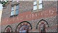
The Geograph project started in 2005 with the aim of publishing, organising and preserving representative images for every square kilometre of Great Britain, Ireland and the Isle of Man.

There are currently over 7.5m images from over14,400 individuals and you can help contribute to the project by visiting https://www.geograph.org.uk
Image Map
Images are licensed for reuse under creativecommons.org/licenses/by-sa/2.0
Notes
- Clicking on the map will re-center to the selected point.
- The higher the marker number, the further away the image location is from the centre of the postcode.
Image Listing (357 Images Found)
Images are licensed for reuse under creativecommons.org/licenses/by-sa/2.0
Image
Details
Distance
1
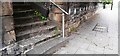
Steps to Beamish Quay from north side of City Road
There is an Ordnance Survey benchmark Image on a stone in the wall on the far side of the steps
Image: © Roger Templeman
Taken: 5 May 2022
0.01 miles
2
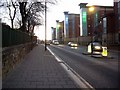
Flats on City Road
Across from St Ann's Church.
Image: © Stephen Sweeney
Taken: 6 Jan 2009
0.02 miles
3

Date plaque on the former Ouseburn Mission House, City Road, NE1
See Image
Image: © Mike Quinn
Taken: 13 Oct 2015
0.02 miles
4
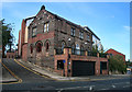
Ouseburn Methodist Mission Hall
The old Ouseburn Methodist Mission Hall which has been home to a number of businesses, most recently an Italian restaurant. Looks now to be a private dwelling house.
Image: © Peter McDermott
Taken: 22 Sep 2012
0.02 miles
5
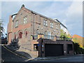
The former Ouseburn Mission House, City Road, NE1
Image: © Mike Quinn
Taken: 13 Oct 2015
0.02 miles
6
Ghost sign on the former Ouseburn Mission House, City Road, NE1
See Image
Image: © Mike Quinn
Taken: 13 Oct 2015
0.02 miles
7
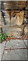
Benchmark on north side of City Road east of steps
Ordnance Survey cut mark benchmark levelled at 23.275m above Newlyn Datum verified 1962
Image: © Roger Templeman
Taken: 5 May 2022
0.04 miles
8
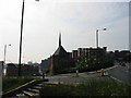
Sailor's Bethel Newcastle
Chapel near the Ouseburn Painted by Lowry
Image: © P Glenwright
Taken: 1 Aug 2004
0.04 miles
9
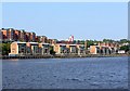
Across the River Tyne from the Baltic
Looking down river to the developments on the Quayside at Mariners Wharf Image and those above (left) of High Quay between Tyne Street and City Road Image Above the central units of Mariners Wharf are the roof-line of the converted warehouse, now Hotel du Vin Image, and the short spire of the Sailors Bethel Image The chimney of the former Maynard's Toffee Factory Image stands beside Glasshouse Bridge over the Ouseburn.
Tom Collins House, part of the Byker Wall, Image is in the distance, and to the right, the buildings on the east bank of the Ouseburn Image On the extreme right are Image with the spire of Image visible above.
There is a view west from the mouth of the Ouseburn here Image
Image: © Andrew Curtis
Taken: 4 Jul 2011
0.04 miles
10
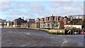
Newcastle Quayside west of Ouseburn
This view takes in Mariners Wharf and London Wharf on Newcastle's Quayside, just east of the Millennium Bridge. The spire of St Ann's Church Image can be seen above the blocks of new apartments. Sailor's Bethel Image with its short, silvery spire is visible on the right. The small boats on the right are at the mouth of the Ouseburn.
Image: © Andrew Curtis
Taken: 28 Mar 2010
0.04 miles