IMAGES TAKEN NEAR TO
Ouse Street, NEWCASTLE UPON TYNE, NE1 2DQ
Introduction
This page details the photographs taken nearby to Ouse Street, NE1 2DQ by members of the Geograph project.
The Geograph project started in 2005 with the aim of publishing, organising and preserving representative images for every square kilometre of Great Britain, Ireland and the Isle of Man.

There are currently over 7.5m images from over14,400 individuals and you can help contribute to the project by visiting https://www.geograph.org.uk
Image Map (Loading...)


Getting Data...Please wait
Leaflet Map data © OpenStreetMap
Images are licensed for reuse under creativecommons.org/licenses/by-sa/2.0
Notes
- Clicking on the map will re-center to the selected point.
- The higher the marker number, the further away the image location is from the centre of the postcode.
Image Listing (349 Images Found)
Images are licensed for reuse under creativecommons.org/licenses/by-sa/2.0
Image
Details
Distance
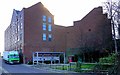
2
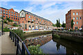
New apartment block, Ouse Street
Housing development of 28 riverside apartments and four new shops or offices at Lower Steenbergs Yard, on Ouse Street in Ouseburn.
https://www.chroniclelive.co.uk/news/north-east-news/derelict-land-heart-ouseburn-finally-15527346 https://web.archive.org/web/20210604182533if_/https://www.chroniclelive.co.uk/news/north-east-news/derelict-land-heart-ouseburn-finally-15527346
https://www.chroniclelive.co.uk/news/north-east-news/stunning-pictures-ouseburn-development-newcastle-18809248 https://web.archive.org/web/20210604184020if_/https://www.chroniclelive.co.uk/news/north-east-news/stunning-pictures-ouseburn-development-newcastle-18809248
There was a building here built around 1860. It was possibly the slaughterhouse owned by a Mr Burns. Newcastle Council bought it in 1876 and it is possible that part of it continued as a slaughterhouse, but the main part was a marshalling area for the cattle who had been quarantined for 24 hours in the adjacent Cattle Sanatorium ready for them to be collected by their owners. The Sanatorium became disused from 1900 and the warehouse building was possibly used as a store or sawmill by timber exporters Robson and Miller. On mid C20 maps it is labelled as an oil works (possibly owned by R.M. Rodgers, Oil Merchant from Elswick Court) and warehouse (owned by Steenbergs). The building was demolished in 2000 but part of the rear wall survives covered in white ceramic tiles. The wall fronting onto Ouse Street retains openings which may have been used for pipes for pumping out the finished oil. The oil business ended around 1950.
Sitelines: https://sitelines.newcastle.gov.uk/SMR/11743 https://web.archive.org/web/20210604183306/https://sitelines.newcastle.gov.uk/SMR/11743
Image: © Andrew Curtis
Taken: 3 Jun 2021
0.01 miles
3
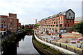
Regeneration on the Ouseburn
The lower Ouseburn valley is an old industrial and port area on the east side of Newcastle-upon-Tyne. It is the subject of an ongoing regeneration project including the Hotel du Vin, the Seven Stories Centre for Children's Books and the Cluny Music Venue. This area towards the lower end on the east bank is obviously next for redevelopment. The riverside path has just been completed. The end of the Byker Wall can be seen on the skyline.
Image: © Oliver Dixon
Taken: 12 Jun 2011
0.01 miles
4
Ouseburn Riverside Walkway
The walkway along the east bank of the Ouse Burn was opened in July 2011.
Image: © Andrew Curtis
Taken: 19 Feb 2012
0.02 miles
5
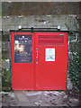
Victoria Tunnel Entrances
Built between 1839-1842 to transport coal from Spital Tongues to the River Tyne.
Entrances on Ouse Street.
Image: © peter maddison
Taken: 13 Nov 2010
0.02 miles
6
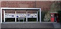
Victoria Tunnel information display & entrance, Ouse Street
Image: © Andrew Curtis
Taken: 19 Feb 2012
0.02 miles
7
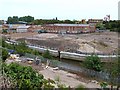
Lower Ouseburn
Looking north up the valley over Ouseburn Bridge back towards the high level bridges. The current Ouseburn Bridge was built in 1878 on the site of an earlier bridge which connected Cut Bank to the Shields Road turnpike via Byker Bank. Unlike Byker Bridge, built at the same time, it was built at the expense of Newcastle Corporation and was always free from tolls.
The derelict area on the west bank of the river, was the site of a Cattle Sanatorium built in 1876, a facility to quarantine more than 600 cattle and 3000 sheep, imported live to Newcastle Quayside, mostly from Scandinavia. It had closed by 1893 and was largely derelict until demolished in 2005 http://www.twsitelines.info/siteline.nsf/SMR/2068121C1B40460B802576AF003E6B5B
Ouseburn Glassworks was on the east bank, one of six glassworks in the Ouseburn valley in 1838, when they provided half of the UK's glass requirement. Little remains today Image although the photographer's location is still known as Glasshouse Bridge.
The 1896 OS Town Plan (1:500) shows the presence of a sewer outfall just this side of the bridge which would have added to the unpleasantness of the area particularly at low tide. It was a crowded home to many people alongside heavy and often dangerous industry.
The photo shows the former industrial land still available for redevelopment and the now completed walkway along the east bank Image
Image: © Andrew Curtis
Taken: 19 Feb 2012
0.03 miles
8

Ouse Burn
Looking down Ouse Burn from the bridge at the bottom of Byker Bank.
Image: © Peter McDermott
Taken: 23 Aug 2008
0.03 miles
9
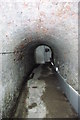
Victoria Tunnel
The Victoria Tunnel in 1939 was converted into a communal air raid shelter for 9,000 people. Wooden benches and bunks were installed as well as chemical toilets and blast walls; electric lighting was fitted and a new concrete floor was laid.
Image: © peter maddison
Taken: 13 Nov 2010
0.03 miles
10
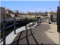
Hotel du Vin & Victoria Tunnel entrance, Ouse Street
Within the small square is a covered display about the Victoria Tunnel Image and the entrance used for public tours Image
Pre-booking is necessary via the Ouseburn Trust http://ouseburntrust.org.uk/index.php?page=victoria-tunnel
Image: © Andrew Curtis
Taken: 19 Feb 2012
0.03 miles