IMAGES TAKEN NEAR TO
Crawhall Road, NEWCASTLE UPON TYNE, NE1 2BX
Introduction
This page details the photographs taken nearby to Crawhall Road, NE1 2BX by members of the Geograph project.
The Geograph project started in 2005 with the aim of publishing, organising and preserving representative images for every square kilometre of Great Britain, Ireland and the Isle of Man.

There are currently over 7.5m images from over14,400 individuals and you can help contribute to the project by visiting https://www.geograph.org.uk
Image Map
Images are licensed for reuse under creativecommons.org/licenses/by-sa/2.0
Notes
- Clicking on the map will re-center to the selected point.
- The higher the marker number, the further away the image location is from the centre of the postcode.
Image Listing (241 Images Found)
Images are licensed for reuse under creativecommons.org/licenses/by-sa/2.0
Image
Details
Distance
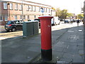
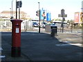
1

Edward VII postbox, Crawhall Road, NE1
Image: © Mike Quinn
Taken: 1 Nov 2011
0.01 miles
5
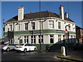
The Tanners, New Bridge Road / Crawhall Road, NE1
Image: © Mike Quinn
Taken: 1 Nov 2011
0.03 miles
6

Sign for The Tanners, New Bridge Road / Crawhall Road, NE1
See Image
Image: © Mike Quinn
Taken: 1 Nov 2011
0.03 miles
7
Roots and Wings Studio, Stepney Bank
Roots and Wings Studio at the top of Stepney Bank in the Ouseburn Valley, Newcastle-upon-Tyne
Image: © Jake Conrad
Taken: 8 Apr 2014
0.04 miles
8

New Bridge Street, with wall overlooking railway
There is an Ordnance Survey benchmark Image on the near end of the wall pier, 2nd stone above the pavement
Image: © Roger Templeman
Taken: 5 May 2022
0.04 miles
9
New Bridge Street / Crawhall Road, NE1
Shows the location of Image
Image: © Mike Quinn
Taken: 1 Nov 2011
0.04 miles
10
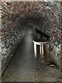
Victoria Tunnel
Victoria Tunnel, 85 ft below the streets of Newcastle. Built to take coal from a colliery beside the town moor down to staithes at Ouseburn, the tunnel is 2 1/2 miles long and opened in 1842. Sets of 8 wagons were rope hauled by a stationary steam engine at the colliery. Though massively reducing the transit costs for the colliery, the colliery itself wasn’t a success and closed in 1860, the tunnel working for only 18 years. Largely forgotten until use as an air raid shelter in WW2, now the bottom section is open to public tours. The central section contains a large bore pipe that is the storm drain for the central motorway, the upper section is accessible but not open to the public
Image: © David Robinson
Taken: 2 Sep 2018
0.05 miles