IMAGES TAKEN NEAR TO
City Road, NEWCASTLE UPON TYNE, NE1 2AN
Introduction
This page details the photographs taken nearby to City Road, NE1 2AN by members of the Geograph project.
The Geograph project started in 2005 with the aim of publishing, organising and preserving representative images for every square kilometre of Great Britain, Ireland and the Isle of Man.

There are currently over 7.5m images from over14,400 individuals and you can help contribute to the project by visiting https://www.geograph.org.uk
Image Map
Images are licensed for reuse under creativecommons.org/licenses/by-sa/2.0
Notes
- Clicking on the map will re-center to the selected point.
- The higher the marker number, the further away the image location is from the centre of the postcode.
Image Listing (567 Images Found)
Images are licensed for reuse under creativecommons.org/licenses/by-sa/2.0
Image
Details
Distance
1
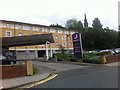
Premier Inn Newcastle City Centre Millennium Bridge
Image: © Darrin Antrobus
Taken: 3 Jun 2014
0.00 miles
2
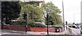
Junction of Crawhall Road and City Road
There is an Ordnance Survey benchmark Image on the brick wall
Image: © Roger Templeman
Taken: 5 May 2022
0.02 miles
3

Benchmark on wall of Crawhall Road at junction with City Road
Ordnance Survey documents describe a cut mark benchmark levelled at 21.740m above Newlyn Datum verified 1962 on a works at this location. I wonder if this is the same mark repositioned as the works have been replaced by housing
Image: © Roger Templeman
Taken: 5 May 2022
0.03 miles
4
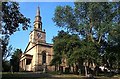
St. Ann's Church, Battlefield, Newcastle upon Tyne
Image: © Bill Henderson
Taken: Unknown
0.04 miles
5
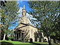
St Ann, City Road, Newcastle
A handsome Georgian church by William Newton, 1764-68, with a Doric portico and four-stage tower at its west end. Grade I listed.
A better view and more info: Image
==========================================================
Newton (1730-98) was one of a breed of skilled, provincial builder-architects who, during the C18th and C19th, created substantial parts of the built fabric of the country that we see today. He spent the whole of his life in Newcastle and established a large practice in the region, mostly building or remodelling country houses, but also designing a number of public buildings and housing in the city. Colvin's Dictionary of British Architects describes him as a "competent but conventional Georgian architect whose work is sometimes elegant, always pleasing, but never remarkable."
==========================================================
Image: © Stephen Richards
Taken: 14 Aug 2012
0.04 miles
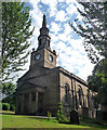
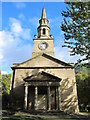
6
The Church of St. Ann, City Road, NE1 (2)
See Image
Image: © Mike Quinn
Taken: 13 Oct 2015
0.04 miles
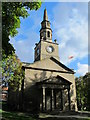
7
The Church of St. Ann, City Road, NE1 - porch and tower
See Image
Image: © Mike Quinn
Taken: 13 Oct 2015
0.04 miles
8
The Church of St. Ann, City Road, NE1 (3)
See Image
Image: © Mike Quinn
Taken: 13 Oct 2015
0.04 miles
9
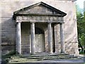
The Church of St. Ann, City Road, NE1 - porch
See Image
Image: © Mike Quinn
Taken: 13 Oct 2015
0.04 miles
10

Benchmark on SW corner, S face of St Ann's Church
Ordnance Survey 1GL bolt benchmark levelled at 28.563m above Newlyn Datum verified 1962. The mark was previously levelled at 93.649 feet above Liverpool Datum during the 1844-1845 1GL Carlisle to North Shields Survey. The surveyor's description was 'Mark No. 187. Bolt in S.W. corner of S. face of St. Ann's Church, New-road ; 1.57 ft. above surface
Image: © Roger Templeman
Taken: 5 May 2022
0.04 miles