IMAGES TAKEN NEAR TO
Leybourne Dene, NEWCASTLE UPON TYNE, NE12 7AQ
Introduction
This page details the photographs taken nearby to Leybourne Dene, NE12 7AQ by members of the Geograph project.
The Geograph project started in 2005 with the aim of publishing, organising and preserving representative images for every square kilometre of Great Britain, Ireland and the Isle of Man.

There are currently over 7.5m images from over14,400 individuals and you can help contribute to the project by visiting https://www.geograph.org.uk
Image Map (Loading...)


Getting Data...Please wait
Leaflet Map data © OpenStreetMap
Images are licensed for reuse under creativecommons.org/licenses/by-sa/2.0
Notes
- Clicking on the map will re-center to the selected point.
- The higher the marker number, the further away the image location is from the centre of the postcode.
Image Listing (15 Images Found)
Images are licensed for reuse under creativecommons.org/licenses/by-sa/2.0
Image
Details
Distance
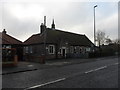
1
Extension to The Percy Hedley Senior School
Image: © Alex McGregor
Taken: 8 Jun 2011
0.12 miles
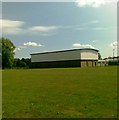
2
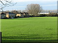
Area of Public Open Space, Killingworth Village
This large area of public open space lies adjacent to a public footpath linking Killingworth Village with Great Lime Road https://www.geograph.org.uk/photo/6694298. For a selection of detailed free to download walking routes in the area visit www.northtynesidewalks.co.uk
Image: © Geoff Holland
Taken: 1 Dec 2020
0.13 miles
3
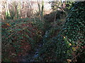
The 'Forest Hall' Letch near Killingworth Village
The Letch flows in two separate strands, the 'Longbenton' Letch and the 'Forest Hall' Letch. In 2016 a £6 million scheme to alleviate flooding in North Tyneside was carried out which involved water, flowing into the sewer network from Killingworth Lake and the 'Longbenton' Letch, being diverted to the 'Forest Hall' Letch via a new 700 metre long underground surface water pipe. For a selection of detailed free to download walking routes in the area visit www.northtynesidewalks.co.uk
Image: © Geoff Holland
Taken: 1 Dec 2020
0.15 miles
4
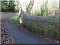
Bridge over the 'Forest Hall' Letch near Killingworth Village
The Letch flows in two separate strands, the 'Longbenton' Letch and the 'Forest Hall' Letch. In 2016 a £6 million scheme to alleviate flooding in North Tyneside was carried out which involved water, flowing into the sewer network from Killingworth Lake and the 'Longbenton' Letch, being diverted to the 'Forest Hall' Letch via a new 700 metre long underground surface water pipe. This bridge carries a public footpath, which links Killingworth Village with Great Lime Road, over the 'Forest Hall' Letch. The word 'Letch' means, "a stream or pool in boggy land" and its use in this area is rare (see Sandy's Letch near Burradon House https://www.geograph.org.uk/photo/6679397). For a selection of detailed free to download walking routes in the area visit www.northtynesidewalks.co.uk
Image: © Geoff Holland
Taken: 1 Dec 2020
0.16 miles
5
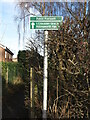
Sign, Great Lime Road near Forest Hall
This sign points the way to Killingworth Village along a delightful public footpath which passes, along the way, deciduous woodland https://www.geograph.org.uk/photo/6694301 and a large area of public open space https://www.geograph.org.uk/photo/6694313. For a selection of detailed free to download walking routes in the area visit www.northtynesidewalks.co.uk
Image: © Geoff Holland
Taken: 1 Dec 2020
0.19 miles
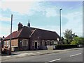
6
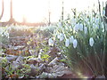
Snowdrops in St John's Churchyard, Killingworth
Image: © Andrew Tryon
Taken: 18 Feb 2007
0.19 miles
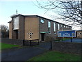
7
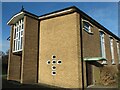
St. Mary of the Rosary Church, Forest Hall
Built in 1961 to designs by Edward Gunning of Eldon Square, Newcastle Upon Tyne, this church has been described as being, "designed in a quiet contemporary style, built of dark russet brick with paler panels flanking the entrance and darker bricks forming the window jambs". Whilst it faces the busy Great Lime Road, the setting has an overall feeling of peacefulness. For a selection of detailed free to download walking routes in the area visit www.northtynesidewalks.co.uk
Image: © Geoff Holland
Taken: 1 Dec 2020
0.21 miles