IMAGES TAKEN NEAR TO
Marston, NEWCASTLE UPON TYNE, NE12 6QF
Introduction
This page details the photographs taken nearby to Marston, NE12 6QF by members of the Geograph project.
The Geograph project started in 2005 with the aim of publishing, organising and preserving representative images for every square kilometre of Great Britain, Ireland and the Isle of Man.

There are currently over 7.5m images from over14,400 individuals and you can help contribute to the project by visiting https://www.geograph.org.uk
Image Map (Loading...)


Getting Data...Please wait
Leaflet Map data © OpenStreetMap
Images are licensed for reuse under creativecommons.org/licenses/by-sa/2.0
Notes
- Clicking on the map will re-center to the selected point.
- The higher the marker number, the further away the image location is from the centre of the postcode.
Image Listing (8 Images Found)
Images are licensed for reuse under creativecommons.org/licenses/by-sa/2.0
Image
Details
Distance
4
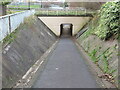
Underpass near Killingworth
This underpass links the urban sprawl of Killingworth New Town with the network of old waggonways and footpaths lying to the north. For a selection of detailed free to download walking routes in the area visit www.northtynesidewalks.co.uk
Image: © Geoff Holland
Taken: 17 Nov 2020
0.18 miles
5
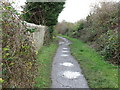
Public Bridleway near Burradon
This public bridleway links the urban sprawl of Killingworth New Town with a plethora of footpaths and tracks. This bridleway follows the course of an old mineral railway which linked Burradon Colliery to the immediate north with Killingworth Colliery to the south. For a selection of detailed free to download walking routes in the area visit www.northtynesidewalks.co.uk
Image: © Geoff Holland
Taken: 17 Nov 2020
0.19 miles
6
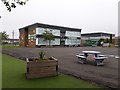
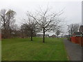
Bailey Green Primary School, West Bailey, Killingworth
A large primary school located on the north side of West Bailey in Killingworth.
Image: © Graham Robson
Taken: 13 Jun 2020
0.21 miles
7
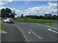
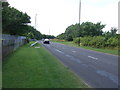
Killingworth Way (A1056)
Approaching roundabout.
Image: © JThomas
Taken: 3 Aug 2013
0.23 miles