IMAGES TAKEN NEAR TO
Chestnut Close, NEWCASTLE UPON TYNE, NE12 6GL
Introduction
This page details the photographs taken nearby to Chestnut Close, NE12 6GL by members of the Geograph project.
The Geograph project started in 2005 with the aim of publishing, organising and preserving representative images for every square kilometre of Great Britain, Ireland and the Isle of Man.

There are currently over 7.5m images from over14,400 individuals and you can help contribute to the project by visiting https://www.geograph.org.uk
Image Map
Images are licensed for reuse under creativecommons.org/licenses/by-sa/2.0
Notes
- Clicking on the map will re-center to the selected point.
- The higher the marker number, the further away the image location is from the centre of the postcode.
Image Listing (14 Images Found)
Images are licensed for reuse under creativecommons.org/licenses/by-sa/2.0
Image
Details
Distance
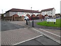
1
Chaffinch Way, Killingworth
A residential street in the western part of Killingworth. Several of the streets in the local area are named after species of bird.
Image: © Graham Robson
Taken: 13 Jun 2020
0.07 miles
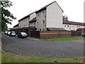
2
Mallard Court, Killingworth
Short terraces of houses in Killingworth. Like the adjacent street, this one takes its name from a species of bird.
Image: © Graham Robson
Taken: 13 Jun 2020
0.10 miles
3
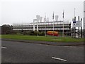
Refurbishment works, council offices, Station Road, Killingworth
The former British Gas facility, turned council offices, is in the process of being refurbished. The building is grade II* listed. https://historicengland.org.uk/listing/the-list/list-entry/1259313
Image: © Graham Robson
Taken: 13 Jun 2020
0.15 miles
4

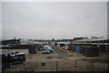
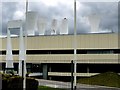
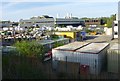
Back of Multi Packaging Solutions, Newcastle
Featuring what looks like a bank of small boilers, but as there is no stack, possibly a bank of fans.
Image: © Robin Webster
Taken: 18 Oct 2019
0.16 miles
5
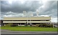
Former British Gas Engineering Research Station, Killingworth (roof detail)
The building is shown here Image
The arch on the left spans an entrance bridge. On the roof is a group of six towers, three venturi formed ventilation flues and three water storage tanks.
Image: © Andrew Curtis
Taken: 29 Apr 2010
0.16 miles
6
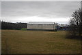
Former British Gas Engineering Research Station, Killingworth
Designed in 1967 by architect Peter Yates http://en.wikipedia.org/wiki/Peter_Yates,_artist_and_architect of the Newcastle partnership, Ryder & Yates. Discussion of the architecture of this building with its dramatic roof elements Image can be found here http://www.c20society.org.uk/botm/archive/2004/engineering-research-station-killingworth.html
It is a listed building now occupied by the Planning Department of North Tyneside Council.
Image: © Andrew Curtis
Taken: 29 Apr 2010
0.16 miles
9
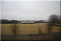
British Gas Engineering Research Station, Killingworth
Note the curious structures on the roof.
Image: © Russel Wills
Taken: 17 May 2014
0.20 miles