IMAGES TAKEN NEAR TO
St. Omers Road, GATESHEAD, NE11 9EZ
Introduction
This page details the photographs taken nearby to St. Omers Road, NE11 9EZ by members of the Geograph project.
The Geograph project started in 2005 with the aim of publishing, organising and preserving representative images for every square kilometre of Great Britain, Ireland and the Isle of Man.

There are currently over 7.5m images from over14,400 individuals and you can help contribute to the project by visiting https://www.geograph.org.uk
Image Map
Images are licensed for reuse under creativecommons.org/licenses/by-sa/2.0
Notes
- Clicking on the map will re-center to the selected point.
- The higher the marker number, the further away the image location is from the centre of the postcode.
Image Listing (33 Images Found)
Images are licensed for reuse under creativecommons.org/licenses/by-sa/2.0
Image
Details
Distance
1

Colliery Road, Dunston
While most of this area of Dunston along the river has been redeveloped with new housing, there are still a couple of surviving old terraces like this one. The name is a reminder of the areas mining past.
Image: © Robert Graham
Taken: 8 Aug 2012
0.03 miles
3
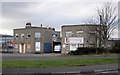
Concrete products business, St Omers Road, Dunston
Image: © Andrew Curtis
Taken: 1 Mar 2012
0.07 miles
6
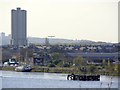
Dunston shore from Elswick
Distant view of the Dunston Rocket Image and Gateshead's Angel of the North Image from the north bank of the River Tyne.
Image: © Andrew Curtis
Taken: 22 Apr 2010
0.09 miles
7
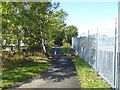
Keelman's Way off Railway Street
At this point the Keelman's Way (National Cycle Network route 114) follows this length of path between Railway Street (to the left) and commercial premises.
Image: © Oliver Dixon
Taken: 19 Sep 2017
0.09 miles
8

Keelman's Way on Handy Drive
At this point the Keelman's Way (National Cycle Network route 14) follows the footway alongside the busy Handy Drive (A1114).
Image: © Oliver Dixon
Taken: 19 Sep 2017
0.10 miles
9
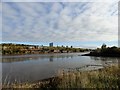
View across Dunston Timber Beach
Looking east, down river. Elswick on the other side of the River Tyne. The name comes from being used to season timber when there was a large timber importers yard here.
Image: © Robert Graham
Taken: 19 Oct 2016
0.11 miles
10
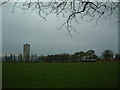
Playing Fields
A little bit of greenery amid the sprawl that is Dunston. As usual in this area of the world, the Rocket makes an appearance.
Image: © Steve McShane
Taken: 3 Dec 2005
0.12 miles