IMAGES TAKEN NEAR TO
Riding Lane, GATESHEAD, NE11 0JA
Introduction
This page details the photographs taken nearby to Riding Lane, NE11 0JA by members of the Geograph project.
The Geograph project started in 2005 with the aim of publishing, organising and preserving representative images for every square kilometre of Great Britain, Ireland and the Isle of Man.

There are currently over 7.5m images from over14,400 individuals and you can help contribute to the project by visiting https://www.geograph.org.uk
Image Map
Images are licensed for reuse under creativecommons.org/licenses/by-sa/2.0
Notes
- Clicking on the map will re-center to the selected point.
- The higher the marker number, the further away the image location is from the centre of the postcode.
Image Listing (3 Images Found)
Images are licensed for reuse under creativecommons.org/licenses/by-sa/2.0
Image
Details
Distance
1
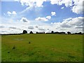
View of Cooper House farm
Looking across the fields from the path north of the farm. This is a large farming establishment that looks as if it could be mid 19th century in origin. It is shown on the first Ordnance Survey maps from that time. Many big farms like this one were established, or old ones enlarged and rebuilt, in this period.
Image: © Robert Graham
Taken: 31 Jul 2013
0.01 miles
2
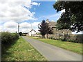
The farmhouse at Cooper House
A large farm on Riding Lane, south of Kibblesworth. This is a small hamlet really, but was probably a big 19th farmstead originally.
Image: © Robert Graham
Taken: 31 Jul 2013
0.02 miles
3
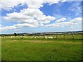
View across the fields near Cooper House farm
Looking east over towards the houses and factories at Birtley from the footpath north of the farm. Penshaw Monument is visible in the far distance to the right.
Image: © Robert Graham
Taken: 31 Jul 2013
0.12 miles