IMAGES TAKEN NEAR TO
Millbrook, GATESHEAD, NE10 9XP
Introduction
This page details the photographs taken nearby to Millbrook, NE10 9XP by members of the Geograph project.
The Geograph project started in 2005 with the aim of publishing, organising and preserving representative images for every square kilometre of Great Britain, Ireland and the Isle of Man.

There are currently over 7.5m images from over14,400 individuals and you can help contribute to the project by visiting https://www.geograph.org.uk
Image Map (Loading...)


Getting Data...Please wait
Leaflet Map data © OpenStreetMap
Images are licensed for reuse under creativecommons.org/licenses/by-sa/2.0
Notes
- Clicking on the map will re-center to the selected point.
- The higher the marker number, the further away the image location is from the centre of the postcode.
Image Listing (6 Images Found)
Images are licensed for reuse under creativecommons.org/licenses/by-sa/2.0
Image
Details
Distance
1
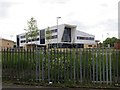
The Thomas Hepburn Community College
Secondary school, Felling.
Image: © Richard Webb
Taken: 18 Jun 2013
0.07 miles
2
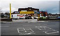
The Ship, High Heworth
Recently converted from a pub into shops.
Image: © Christine Johnstone
Taken: 25 Feb 2017
0.14 miles
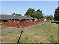
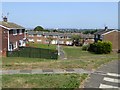
4
Smithburn Road
Housing estate, Felling. A lot of the roads are cul-de-sacs with houses arranged around a circular turning area at the end of the road.
Image: © Richard Webb
Taken: 18 Jun 2013
0.22 miles
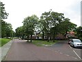
6
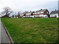
Houses on Colegate West
The road has been lowered to pass under former railway lines.
Image: © Christine Johnstone
Taken: 25 Feb 2017
0.25 miles