IMAGES TAKEN NEAR TO
Elliott Drive, GATESHEAD, NE10 9QZ
Introduction
This page details the photographs taken nearby to Elliott Drive, NE10 9QZ by members of the Geograph project.
The Geograph project started in 2005 with the aim of publishing, organising and preserving representative images for every square kilometre of Great Britain, Ireland and the Isle of Man.

There are currently over 7.5m images from over14,400 individuals and you can help contribute to the project by visiting https://www.geograph.org.uk
Image Map (Loading...)


Getting Data...Please wait
Leaflet Map data © OpenStreetMap
Images are licensed for reuse under creativecommons.org/licenses/by-sa/2.0
Notes
- Clicking on the map will re-center to the selected point.
- The higher the marker number, the further away the image location is from the centre of the postcode.
Image Listing (48 Images Found)
Images are licensed for reuse under creativecommons.org/licenses/by-sa/2.0
Image
Details
Distance
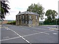
1
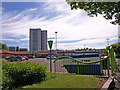
Felling
Red roofed buildings are the council offices, the car park serves the Co-op, taxi services and recycling skips. The Crowhall Towers dominate the background.
Image: © wfmillar
Taken: 3 Jun 2010
0.06 miles
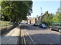
2
Rear of Holly Hill Social Club, Felling
Photographed from Booth Street.
Image: © Andrew Curtis
Taken: 16 Jul 2010
0.07 miles
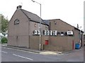
3
Crossroads, Holly Hill and Davidson Street, Felling
Image: © Andrew Curtis
Taken: 16 Jul 2010
0.09 miles


6
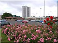
Car Park, Felling Shopping Centre
Car park entrances are from Holly Hill and Booth Street.
Image: © Andrew Curtis
Taken: 16 Jul 2010
0.11 miles
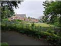
7

Felling Park
Opened in July 1910, around the impressive Felling Town Hall which was built in 1902.
Tyne and Wear HER (5253): Felling Park http://www.twsitelines.info
There are spectacular displays of bedding plants on the slope which rises from Sunderland Road to Holly Hill. There is another view here Image
Image: © Andrew Curtis
Taken: 16 Jul 2010
0.11 miles
8

Felling Park
Sunderland Road is below, to the right.
Image: © Andrew Curtis
Taken: 16 Jul 2010
0.11 miles