IMAGES TAKEN NEAR TO
Parklands, GATESHEAD, NE10 8YP
Introduction
This page details the photographs taken nearby to Parklands, NE10 8YP by members of the Geograph project.
The Geograph project started in 2005 with the aim of publishing, organising and preserving representative images for every square kilometre of Great Britain, Ireland and the Isle of Man.

There are currently over 7.5m images from over14,400 individuals and you can help contribute to the project by visiting https://www.geograph.org.uk
Image Map (12 Images)


Getting Data...Please wait
Leaflet Map data © OpenStreetMap
Images are licensed for reuse under creativecommons.org/licenses/by-sa/2.0
Notes
- Clicking on the map will re-center to the selected point.
- The higher the marker number, the further away the image location is from the centre of the postcode.
Image Listing (12 Images Found)
Images are licensed for reuse under creativecommons.org/licenses/by-sa/2.0
Image
Details
Distance
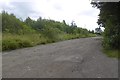
3
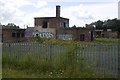
Site of Wardley Colliery
The building appears to have had post colliery industrial use.
Image: © Richard Webb
Taken: 9 Aug 2016
0.13 miles
4
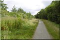
East Gateshead Cycle Path
Path beside the railway at Wardley. This was once coal mining and clay pit land.
Image: © Richard Webb
Taken: 9 Aug 2016
0.16 miles
5
Rough track, Wardley
Potholed, this was once the access route to Wardley Colliery
Image: © Richard Webb
Taken: 9 Aug 2016
0.18 miles
6
Leamside Line
Closed in 1991, the tracks are still in place along much of its length although now useless. There are repeated calls for the railway to be reopened.
Image: © Richard Webb
Taken: 9 Aug 2016
0.19 miles
7
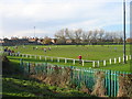
Former Wardley Colliery Welfare Sports Ground
Image: © Les Hull
Taken: 15 Nov 2009
0.21 miles
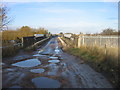
9
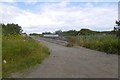
Colliery road, Wardley
Crossing the railway to Sunderland, this potholed road once served Wardley Colliery.
Image: © Richard Webb
Taken: 9 Aug 2016
0.21 miles
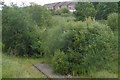
10

Leamside Railway, Wardley
The overgrown railway, closed in the 1990s. View from the Bowes Railway overbridge.
Image: © Richard Webb
Taken: 9 Aug 2016
0.23 miles