IMAGES TAKEN NEAR TO
Glynfellis, GATESHEAD, NE10 8RJ
Introduction
This page details the photographs taken nearby to Glynfellis, NE10 8RJ by members of the Geograph project.
The Geograph project started in 2005 with the aim of publishing, organising and preserving representative images for every square kilometre of Great Britain, Ireland and the Isle of Man.

There are currently over 7.5m images from over14,400 individuals and you can help contribute to the project by visiting https://www.geograph.org.uk
Image Map (Loading...)


Getting Data...Please wait
Leaflet Map data © OpenStreetMap
Images are licensed for reuse under creativecommons.org/licenses/by-sa/2.0
Notes
- Clicking on the map will re-center to the selected point.
- The higher the marker number, the further away the image location is from the centre of the postcode.
Image Listing (13 Images Found)
Images are licensed for reuse under creativecommons.org/licenses/by-sa/2.0
Image
Details
Distance
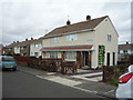
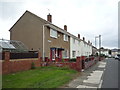
1
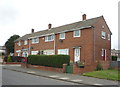
Houses on Leam Lane, Gateshead
Showing position of Postbox No. NE10 149.
See Image] for postbox.
Image: © JThomas
Taken: 18 Aug 2018
0.06 miles
2
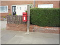
Elizabeth II postbox on Leam Lane, Gateshead
Image: © JThomas
Taken: 18 Aug 2018
0.07 miles
3
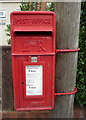
Close up, Elizabeth II postbox on Leam Lane, Gateshead
Postbox No. NE10 149.
See Image] for wider view.
Image: © JThomas
Taken: 18 Aug 2018
0.07 miles
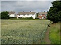
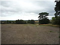
5
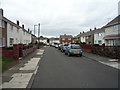
Rickgarth, Gateshead NE10
Looking north west.
Image: © JThomas
Taken: 18 Aug 2018
0.10 miles