IMAGES TAKEN NEAR TO
The Willows, GATESHEAD, NE10 8BW
Introduction
This page details the photographs taken nearby to The Willows, NE10 8BW by members of the Geograph project.
The Geograph project started in 2005 with the aim of publishing, organising and preserving representative images for every square kilometre of Great Britain, Ireland and the Isle of Man.

There are currently over 7.5m images from over14,400 individuals and you can help contribute to the project by visiting https://www.geograph.org.uk
Image Map (Loading...)


Getting Data...Please wait
Leaflet Map data © OpenStreetMap
Images are licensed for reuse under creativecommons.org/licenses/by-sa/2.0
Notes
- Clicking on the map will re-center to the selected point.
- The higher the marker number, the further away the image location is from the centre of the postcode.
Image Listing (8 Images Found)
Images are licensed for reuse under creativecommons.org/licenses/by-sa/2.0
Image
Details
Distance
2
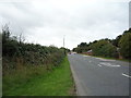
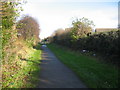
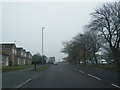
Leam Lane (B1288), Gateshead
Looking south west.
Image: © JThomas
Taken: 18 Aug 2018
0.07 miles
3
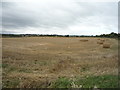
Recently harvested field off Leam Lane, Gateshead
Image: © JThomas
Taken: 18 Aug 2018
0.09 miles
4
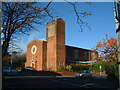
St Augustine's Catholic Church
The Catholic church on Wealcroft, Leam Lane, a stone's throw from the swimming pool.
Image: © Steve McShane
Taken: 5 Nov 2005
0.10 miles
6
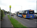
Junction on A195, Lingey Lane
Go north East bus approaching traffic lights on route 57, Wardley - Hadrian Park.
Image: © JThomas
Taken: 18 Aug 2018
0.23 miles
8
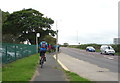
Cycle path and bus stop beside New Road (A195)
Image: © JThomas
Taken: 18 Aug 2018
0.24 miles