IMAGES TAKEN NEAR TO
Corrofell Gardens, GATESHEAD, NE10 0YQ
Introduction
This page details the photographs taken nearby to Corrofell Gardens, NE10 0YQ by members of the Geograph project.
The Geograph project started in 2005 with the aim of publishing, organising and preserving representative images for every square kilometre of Great Britain, Ireland and the Isle of Man.

There are currently over 7.5m images from over14,400 individuals and you can help contribute to the project by visiting https://www.geograph.org.uk
Image Map (Loading...)


Getting Data...Please wait
Leaflet Map data © OpenStreetMap
Images are licensed for reuse under creativecommons.org/licenses/by-sa/2.0
Notes
- Clicking on the map will re-center to the selected point.
- The higher the marker number, the further away the image location is from the centre of the postcode.
Image Listing (45 Images Found)
Images are licensed for reuse under creativecommons.org/licenses/by-sa/2.0
Image
Details
Distance
1
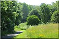
Wild flower meadow
The foot and cycle path from Gateshead to South Shields is about to return to the river side. There is a clearing here, full of flowers.
Image: © Richard Webb
Taken: 18 Jun 2013
0.04 miles
2
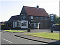
Maiden Over
Crickety 1950's suburban pub on Low Heworth Lane.
Image: © MSX
Taken: 14 Jul 2006
0.04 miles
3
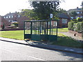
Old Style Bus Shelter On Gosforth Terrace
Don't see many of these any more. Used to be the punk stop where the punks hung out being punks.
Image: © MSX
Taken: 14 Jul 2006
0.04 miles
4
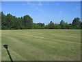
Pelaw Fields West
Covers an area roughly the same as Pelaw.
Image: © MSX
Taken: 14 Jul 2006
0.04 miles
5
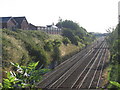
Railway And Last CWS Factory
Looking Eastward from Kirkstone Road, the factory on the left is the old Co-Op Shirt Factory.
Image: © MSX
Taken: 14 Jul 2006
0.04 miles
8
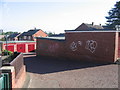
Wynn Gardens Lock-Ups
Council garages with really rubbish tags on the side.
Image: © MSX
Taken: 14 Jul 2006
0.04 miles
9
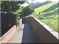
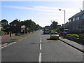
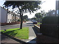
Lane To Wynn Gardens
Winding lane to housing estate.
Image: © MSX
Taken: 14 Jul 2006
0.04 miles