IMAGES TAKEN NEAR TO
Morven Drive, GATESHEAD, NE10 0TG
Introduction
This page details the photographs taken nearby to Morven Drive, NE10 0TG by members of the Geograph project.
The Geograph project started in 2005 with the aim of publishing, organising and preserving representative images for every square kilometre of Great Britain, Ireland and the Isle of Man.

There are currently over 7.5m images from over14,400 individuals and you can help contribute to the project by visiting https://www.geograph.org.uk
Image Map (Loading...)


Getting Data...Please wait
Leaflet Map data © OpenStreetMap
Images are licensed for reuse under creativecommons.org/licenses/by-sa/2.0
Notes
- Clicking on the map will re-center to the selected point.
- The higher the marker number, the further away the image location is from the centre of the postcode.
Image Listing (123 Images Found)
Images are licensed for reuse under creativecommons.org/licenses/by-sa/2.0
Image
Details
Distance
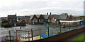
1
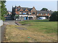
Shields Road / Station Road Junction
At junction lies the old Co-Op building.
Image: © MSX
Taken: 25 Jul 2006
0.12 miles
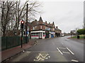
3

John Brown's
Old newsagent's now bikeshop on the corner of Coxon (ghost) Street.
Image: © MSX
Taken: 19 Jul 2006
0.14 miles
4
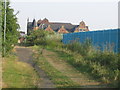
Former Railway Bridge
This hump in the path is a filled in footbridge. Beyond is the old Co-Op building.
Image: © MSX
Taken: 25 Jul 2006
0.16 miles
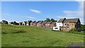
6
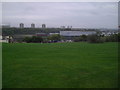
Bill Quay Fields
Once, terraces ran all the way to the Tyne here, it was then a huge scrapyard and finally in the mid 1970s it was cleared to make these rolling hills.
Image: © MSX
Taken: 15 Oct 2005
0.21 miles
7
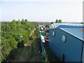
Station Road From Footbridge
The path of the old Dilly Lines leads on to Station Road and Bill Quay.
Image: © MSX
Taken: 25 Jul 2006
0.21 miles
8
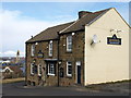
The Cricketers, Bill Quay
Looking past The Cricketers over The Albion to the Tyne.
Image: © wfmillar
Taken: 22 Mar 2008
0.21 miles
9
Cromwell Road
A pub is all that remains of Joel Terrace, a demolished residential street. Houses on the west side of Cromwell Road survive.
Image: © Richard Webb
Taken: 18 Jun 2013
0.21 miles