IMAGES TAKEN NEAR TO
Woodgate Gardens, GATESHEAD, NE10 0ST
Introduction
This page details the photographs taken nearby to Woodgate Gardens, NE10 0ST by members of the Geograph project.
The Geograph project started in 2005 with the aim of publishing, organising and preserving representative images for every square kilometre of Great Britain, Ireland and the Isle of Man.

There are currently over 7.5m images from over14,400 individuals and you can help contribute to the project by visiting https://www.geograph.org.uk
Image Map
Images are licensed for reuse under creativecommons.org/licenses/by-sa/2.0
Notes
- Clicking on the map will re-center to the selected point.
- The higher the marker number, the further away the image location is from the centre of the postcode.
Image Listing (9 Images Found)
Images are licensed for reuse under creativecommons.org/licenses/by-sa/2.0
Image
Details
Distance
1
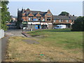
Shields Road / Station Road Junction
At junction lies the old Co-Op building.
Image: © MSX
Taken: 25 Jul 2006
0.16 miles
4
Bridge over the Leamside Line
The railway is disused and now well wooded. Bridges are being maintained, there is a hope of reopening the line one day.
Image: © Richard Webb
Taken: 9 Aug 2016
0.18 miles
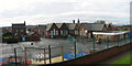
5
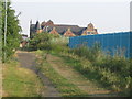
Former Railway Bridge
This hump in the path is a filled in footbridge. Beyond is the old Co-Op building.
Image: © MSX
Taken: 25 Jul 2006
0.18 miles
6
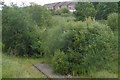
Leamside Line
Closed in 1991, the tracks are still in place along much of its length although now useless. There are repeated calls for the railway to be reopened.
Image: © Richard Webb
Taken: 9 Aug 2016
0.21 miles
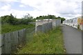
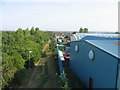
7
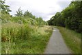
East Gateshead Cycle Path
Path beside the railway at Wardley. This was once coal mining and clay pit land.
Image: © Richard Webb
Taken: 9 Aug 2016
0.21 miles
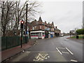
8
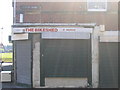
John Brown's
Old newsagent's now bikeshop on the corner of Coxon (ghost) Street.
Image: © MSX
Taken: 19 Jul 2006
0.21 miles
9
Station Road From Footbridge
The path of the old Dilly Lines leads on to Station Road and Bill Quay.
Image: © MSX
Taken: 25 Jul 2006
0.22 miles