IMAGES TAKEN NEAR TO
Crowhall Lane, GATESHEAD, NE10 0NF
Introduction
This page details the photographs taken nearby to Crowhall Lane, NE10 0NF by members of the Geograph project.
The Geograph project started in 2005 with the aim of publishing, organising and preserving representative images for every square kilometre of Great Britain, Ireland and the Isle of Man.

There are currently over 7.5m images from over14,400 individuals and you can help contribute to the project by visiting https://www.geograph.org.uk
Image Map (Loading...)


Getting Data...Please wait
Leaflet Map data © OpenStreetMap
Images are licensed for reuse under creativecommons.org/licenses/by-sa/2.0
Notes
- Clicking on the map will re-center to the selected point.
- The higher the marker number, the further away the image location is from the centre of the postcode.
Image Listing (51 Images Found)
Images are licensed for reuse under creativecommons.org/licenses/by-sa/2.0
Image
Details
Distance
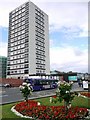
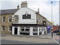
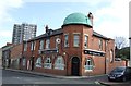
2
The Greyhound, Crowhall Towers, Felling
The Greyhound replaced an original pub of this name which stood in Felling High Street across the road from The Half Way House. At one point its name was changed to the Gray Hound after one of the previous owners http://www.gateshead-history.com/felling.html
Photo of The Greyhound in 1969 http://isee.gateshead.gov.uk/detail.php?t=objects&type=all&f=&s=greyhound&record=0
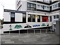
The mosaic artwork along the entrance ramp was by Mark Todman, installed in 2010 http://www.gatesheadhousing.co.uk/site/scripts/news_article.php?newsID=645
Image: © Andrew Curtis
Taken: 16 Jul 2010
0.01 miles
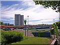
3
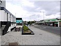
Crowhall Lane, Felling
The Greyhound pub, below Crowhall Towers, is on the left Image and Felling Shopping Centre on the right Image
Image: © Andrew Curtis
Taken: 16 Jul 2010
0.02 miles
4
Car Park, Felling Shopping Centre
Car park entrances are from Holly Hill and Booth Street.
Image: © Andrew Curtis
Taken: 16 Jul 2010
0.08 miles
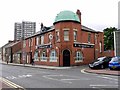
5
Victoria Jubilee, Split Crow Road, Felling
Renamed from the Barley Mow in 1887, the year of the Queen's Jubilee http://www.gateshead-history.com/felling.html
Image: © Andrew Curtis
Taken: 16 Jul 2010
0.08 miles
6
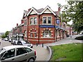
The Blue Bell at Felling, High Street
The pub here was rebuilt by Newcastle Breweries in 1905 on the site of an existing brewery-owned establishment http://www.gateshead-history.com/felling.html
Image: © Andrew Curtis
Taken: 16 Jul 2010
0.09 miles
7
The Portland Arms, Split Crow Road, Felling
Previously the Shakespeare http://www.gateshead-history.com/felling.html
Image: © Andrew Curtis
Taken: 16 Jul 2010
0.09 miles
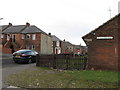
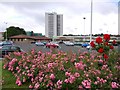
10
Felling
Red roofed buildings are the council offices, the car park serves the Co-op, taxi services and recycling skips. The Crowhall Towers dominate the background.
Image: © wfmillar
Taken: 3 Jun 2010
0.10 miles