IMAGES TAKEN NEAR TO
Fox Street, GATESHEAD, NE10 0BD
Introduction
This page details the photographs taken nearby to Fox Street, NE10 0BD by members of the Geograph project.
The Geograph project started in 2005 with the aim of publishing, organising and preserving representative images for every square kilometre of Great Britain, Ireland and the Isle of Man.

There are currently over 7.5m images from over14,400 individuals and you can help contribute to the project by visiting https://www.geograph.org.uk
Image Map
Images are licensed for reuse under creativecommons.org/licenses/by-sa/2.0
Notes
- Clicking on the map will re-center to the selected point.
- The higher the marker number, the further away the image location is from the centre of the postcode.
Image Listing (22 Images Found)
Images are licensed for reuse under creativecommons.org/licenses/by-sa/2.0
Image
Details
Distance
2
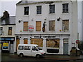
Duke of Connaught
Derelict pub is typical of this stretch of Sunderland Road.
Image: © MSX
Taken: 28 Oct 2005
0.02 miles
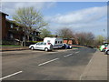
3
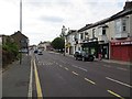
Sunderland Road
Before A Roads and the like, this was the main passage to Sunderland.
Image: © MSX
Taken: 28 Oct 2005
0.14 miles
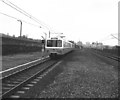
4
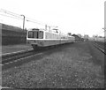
Tyne and Wear Metro at Felling
Car No 4053
Image: © Dr Neil Clifton
Taken: 20 Mar 1982
0.17 miles
5
Tyne and Wear Metro at Felling
Car No 4066
Image: © Dr Neil Clifton
Taken: 20 Mar 1982
0.17 miles
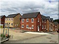
6
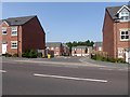
Woodward Avenue
Modern town houses off Sunderland Road.
Image: © Oliver Dixon
Taken: 26 Jul 2018
0.19 miles
7
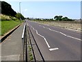
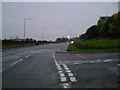
Sunderland Road, Felling
The B1246. The railway and metro to Sunderland lie behind the wall on the right.
Image: © Oliver Dixon
Taken: 26 Jul 2018
0.20 miles
10
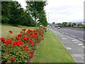
Roses along Sunderland Road
Wooded slopes between Sunderland Road and Felling Gate known as Image
Image: © Andrew Curtis
Taken: 16 Jul 2010
0.21 miles