IMAGES TAKEN NEAR TO
Ainsley Close, LONDON, N9 9XL
Introduction
This page details the photographs taken nearby to Ainsley Close, N9 9XL by members of the Geograph project.
The Geograph project started in 2005 with the aim of publishing, organising and preserving representative images for every square kilometre of Great Britain, Ireland and the Isle of Man.

There are currently over 7.5m images from over14,400 individuals and you can help contribute to the project by visiting https://www.geograph.org.uk
Image Map
Images are licensed for reuse under creativecommons.org/licenses/by-sa/2.0
Notes
- Clicking on the map will re-center to the selected point.
- The higher the marker number, the further away the image location is from the centre of the postcode.
Image Listing (25 Images Found)
Images are licensed for reuse under creativecommons.org/licenses/by-sa/2.0
Image
Details
Distance
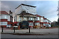
2

Milk & More dairy on Church Street, Edmonton
Image: © David Howard
Taken: 21 Aug 2014
0.10 miles
4
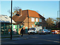
Dairy, Church Street
Near the junction with the A10.
Image: © Robin Webster
Taken: 11 Nov 2012
0.13 miles
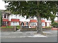
6
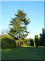
Tree, Edmonton Cemetery
This corner by the entrance has no graves.
Image: © Robin Webster
Taken: 11 Nov 2012
0.15 miles
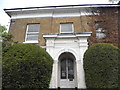
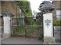
10
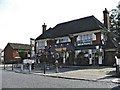
The Beehive public house in Little Bury Street
Image: © Christine Matthews
Taken: 12 Sep 2005
0.15 miles