IMAGES TAKEN NEAR TO
St. Joan's Road, LONDON, N9 9PH
Introduction
This page details the photographs taken nearby to St. Joan's Road, N9 9PH by members of the Geograph project.
The Geograph project started in 2005 with the aim of publishing, organising and preserving representative images for every square kilometre of Great Britain, Ireland and the Isle of Man.

There are currently over 7.5m images from over14,400 individuals and you can help contribute to the project by visiting https://www.geograph.org.uk
Image Map
Images are licensed for reuse under creativecommons.org/licenses/by-sa/2.0
Notes
- Clicking on the map will re-center to the selected point.
- The higher the marker number, the further away the image location is from the centre of the postcode.
Image Listing (58 Images Found)
Images are licensed for reuse under creativecommons.org/licenses/by-sa/2.0
Image
Details
Distance
1
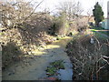
Salmon's Brook in Edmonton
Viewed looking downstream from near the Latymer Road bridge, Salmon's Brook is a tributary of the River Lee.
Image: © Nigel Cox
Taken: 1 Feb 2008
0.03 miles
2
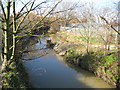
Salmon's Brook in Edmonton
Viewed looking upstream from near Churchfield School.
Image: © Nigel Cox
Taken: 1 Feb 2008
0.04 miles
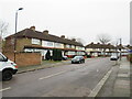
3
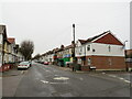
Marlborough Road, Edmonton
Marlborough Road is a short residential road in Edmonton, in the suburbs of north London. Despite being short, the road straddles two Ordnance Survey gridsquares.
Image: © Malc McDonald
Taken: 11 Dec 2021
0.08 miles
4
Marlborough Road, Edmonton
Marlborough Road is a short, residential road in Edmonton, in the suburbs of north London. Despite being short, the road straddles two Ordnance survey gridsquares.
Image: © Malc McDonald
Taken: 11 Dec 2021
0.12 miles
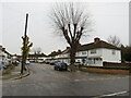
5
Winchester Road, Edmonton
A mini-roundabout at the junction of Winchester Road and Glastonbury Road, two residential roads in Edmonton in the suburbs of north London.
Image: © Malc McDonald
Taken: 11 Dec 2021
0.13 miles
6
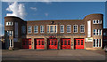
Edmonton Fire Station
Built in 1941 to designs prepared in the Edmonton Architects' Department. (Ref: The Buildings of England. 4: North (1998), p. 425).
Image: © Jim Osley
Taken: 31 Mar 2016
0.15 miles
7

Public footpath, Edmonton
A public footpath between two houses in Edmonton, in north London. The path hides Salmon's Brook, a tributary of the River Lea (or Lee), which flows in a culvert beneath the path here.
Image: © Malc McDonald
Taken: 11 Dec 2021
0.15 miles
8
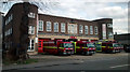
Edmonton Fire Station
Image depicting the frontage and forecourt of London Fire Brigade Edmonton Fire Station including 4 London fire appliances.
Image: © Les Savine
Taken: 27 Mar 2015
0.16 miles
9

Edmonton: Church Street, N9
Three blocks of large Victorian townhouses can be seen on the north side of Church Street between Stanley Road and Arthur Road. The terracotta coloured tablet in the side wall of the nearest group has the date 1881.
Image: © Nigel Cox
Taken: 1 Feb 2008
0.17 miles
10

Edmonton Fire Station
The fire station is at 99 Church Street, N9, and is operated by the LFB (London Fire Brigade), who themselves are run by the LFEPA (London Fire and Emergency Planning Authority).
Image: © Nigel Cox
Taken: 1 Feb 2008
0.17 miles