IMAGES TAKEN NEAR TO
Grosvenor Road, LONDON, N9 8RE
Introduction
This page details the photographs taken nearby to Grosvenor Road, N9 8RE by members of the Geograph project.
The Geograph project started in 2005 with the aim of publishing, organising and preserving representative images for every square kilometre of Great Britain, Ireland and the Isle of Man.

There are currently over 7.5m images from over14,400 individuals and you can help contribute to the project by visiting https://www.geograph.org.uk
Image Map
Images are licensed for reuse under creativecommons.org/licenses/by-sa/2.0
Notes
- Clicking on the map will re-center to the selected point.
- The higher the marker number, the further away the image location is from the centre of the postcode.
Image Listing (45 Images Found)
Images are licensed for reuse under creativecommons.org/licenses/by-sa/2.0
Image
Details
Distance
1

Former Enfield Co-op building
The pediment has a monogram that seems to be E C S, and a date of 1906. This was after the Enfield Highway and Enfield Town Co-operative Societies merged. The row of houses, including houses on this site, is late Victorian, so the shop must have been a rebuild or conversion.
Image: © Robin Webster
Taken: 11 Nov 2012
0.08 miles
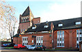
2

International Charismatic Church House of Prayer
The white building is the 'House', formerly a church hall. The building beyond, the former parish church of St. Michael, closed in 1982 and is now flats.
Image: © Robin Webster
Taken: 11 Nov 2012
0.10 miles
3
"The King William IV" public house, Hertford Road, Edmonton
Closed, awaiting re-development.
Image: © Jim Osley
Taken: 28 Jun 2015
0.10 miles
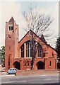
4

St Michael Bassishaw, Bury Street
Redundant church since 1982, now flats
Image: © John Salmon
Taken: 25 Jan 2014
0.11 miles
5
St Michael Bassishaw, Bury
Redundant church since 1982, now flats
Image: © John Salmon
Taken: 25 Jan 2014
0.11 miles
6
St Michael Bassishaw, Bury Street
Redundant church since 1982, now flats
Image: © John Salmon
Taken: Unknown
0.11 miles
7
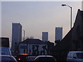
Tower blocks Lower Edmonton
From the usual traffic jam in Hertford Road.
Image: © David Howard
Taken: 29 Jan 2009
0.15 miles
8
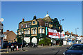
The Cock on Remembrance Sunday
Decorated for the day, and offering OAPs all drinks at £1.50.
Image: © Robin Webster
Taken: 11 Nov 2012
0.17 miles
9
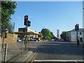
Hertford Road at the junction of Bounces Road
Image: © David Howard
Taken: 18 Jul 2013
0.17 miles
10
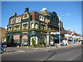
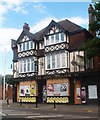
Edmonton: The Cock Tavern, Hertford Road, N9
This pub with its extravagant architecture is on the corner of Houndsfield Road and Hertford Road. A glance at old nineteenth century maps shows that there has been a pub here with the same name since mid-Victorian times at least, although at that time it was the only building along Hertford Road for some distance in each direction.
Hertford Road is the A1010.
Image: © Nigel Cox
Taken: 1 Feb 2008
0.17 miles