IMAGES TAKEN NEAR TO
St. Malo Avenue, LONDON, N9 0SA
Introduction
This page details the photographs taken nearby to St. Malo Avenue, N9 0SA by members of the Geograph project.
The Geograph project started in 2005 with the aim of publishing, organising and preserving representative images for every square kilometre of Great Britain, Ireland and the Isle of Man.

There are currently over 7.5m images from over14,400 individuals and you can help contribute to the project by visiting https://www.geograph.org.uk
Image Map
Images are licensed for reuse under creativecommons.org/licenses/by-sa/2.0
Notes
- Clicking on the map will re-center to the selected point.
- The higher the marker number, the further away the image location is from the centre of the postcode.
Image Listing (39 Images Found)
Images are licensed for reuse under creativecommons.org/licenses/by-sa/2.0
Image
Details
Distance
1
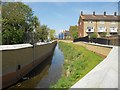
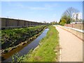
Salmon's Brook in Edmonton (4)
This is a view looking upstream from the Montagu Road culvert showing the new flood defence walls on either side of the brook. Beyond the wall on the left is the Tottenham Park Cemetery. On the right are the housing blocks in Barrowfield Close, which was once the site of the Edmonton Stadium (greyhound racing).
Image: © Nigel Cox
Taken: 5 May 2016
0.10 miles
2
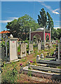
Tottenham Park Cemetery, Upper Edmonton
Used primarily for Muslim burials.
Image: © Jim Osley
Taken: 11 Jun 2017
0.11 miles
3
St Martin (St Demetrios), Town Road, Edmonton - West end
Image: © John Salmon
Taken: 28 Jan 2014
0.11 miles
4
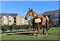
Horse on the Lawn, Montagu Road
This splendid metal horse is in front of a new crescent of houses.
I can find nothing on the web about it.
Image: © Des Blenkinsopp
Taken: 9 Oct 2018
0.12 miles
5
Salmon's Brook in Edmonton (3)
This is a view looking upstream showing the new flood defence walls on either side of the brook. Beyond the higher wall on the left is the Jewish Federation Cemetery.
Image: © Nigel Cox
Taken: 5 May 2016
0.12 miles
6
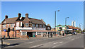
Montagu Road, Edmonton
Featuring the Enfield Food Centre on the corner of Town Road. This is along the final, rather uninspiring lower section of the Pymme's Brook Trail, an urban footpath which follows the brook from near Cockfosters down to Picketts Lock on the River Lee.
Image: © Des Blenkinsopp
Taken: 9 Oct 2018
0.12 miles
7
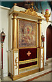
St Martin (St Demetrios), Town Road, Edmonton - Icon
Image: © John Salmon
Taken: 28 Jan 2014
0.13 miles
8

St Martin (St Demetrios), Town Road, Edmonton - Icon
Image: © John Salmon
Taken: 28 Jan 2014
0.13 miles
9

St Martin (St Demetrios), Town Road, Edmonton - Icon
Image: © John Salmon
Taken: 28 Jan 2014
0.13 miles
10

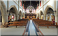
St Martin (St Demetrios), Town Road, Edmonton - Interior
Image: © John Salmon
Taken: 28 Jan 2014
0.13 miles