IMAGES TAKEN NEAR TO
Sebastopol Road, LONDON, N9 0QH
Introduction
This page details the photographs taken nearby to Sebastopol Road, N9 0QH by members of the Geograph project.
The Geograph project started in 2005 with the aim of publishing, organising and preserving representative images for every square kilometre of Great Britain, Ireland and the Isle of Man.

There are currently over 7.5m images from over14,400 individuals and you can help contribute to the project by visiting https://www.geograph.org.uk
Image Map
Images are licensed for reuse under creativecommons.org/licenses/by-sa/2.0
Notes
- Clicking on the map will re-center to the selected point.
- The higher the marker number, the further away the image location is from the centre of the postcode.
Image Listing (13 Images Found)
Images are licensed for reuse under creativecommons.org/licenses/by-sa/2.0
Image
Details
Distance
1
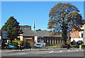
Faith House, Fore Street
A Christian Revival Centre according to the sign on the wall. No more information available. An internet search throws up just one site, which uses the church's name and features a picture of the place, but is actually a hostile blog set up by someone obviously in dispute with whoever runs the church.
Image: © Des Blenkinsopp
Taken: 9 Oct 2018
0.07 miles
2
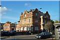
Former public library, Fore Street, N9
Formerly the Passmore Edwards Public Library, which is inscribed over the main front door. Over the door at the rear left is 'EUDC Lending Library 1931'. Passmore Edwards was a great public benefactor, principally of libraries and like in poorer areas. The building is now the Mevlana Rumi Mosque, with a mainly Turkish attendance.
Image: © Robin Webster
Taken: 11 Nov 2012
0.10 miles
4
Faith House, Fore Street, Edmonton, North London
Image: © Jim Osley
Taken: 9 Dec 2010
0.12 miles
6
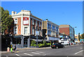
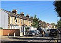
Restaurant on the corner, Fore Street
Still looking very much like a pub, but now trading as the Capital Restaurant.
Image: © Des Blenkinsopp
Taken: 9 Oct 2018
0.14 miles
7

Solomon Avenue, Edmonton
Solomon Avenue is a residential road in a modern housing development in Edmonton, in the suburbs of north London.
Image: © Malc McDonald
Taken: 11 Dec 2021
0.17 miles
8
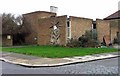
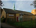
St Mary's Church Centre, Lawrence Road, London N18
Built 1970, architect Brian Freebourne.
Image: © John Salmon
Taken: 23 Jan 2008
0.20 miles
9

Park Road, Edmonton
Park Road is a minor road in Edmonton, in the suburbs of north London. Here, the road passes beneath a railway line. Signs warn that the bridge is low, however the road has subsequently been closed to motor vehicles. Painted markings on the road surface indicate that the road forms part of the route of London's Cycleway 1.
Image: © Malc McDonald
Taken: 11 Dec 2021
0.20 miles
10
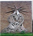
St Mary's Church Centre, Lawrence Road, London N18
Sculpture on exterior wall of St Mary's Church Centre, Lawrence Road, London N18
Image: © John Salmon
Taken: 23 Jan 2008
0.21 miles