IMAGES TAKEN NEAR TO
Montagu Road, LONDON, N9 0HP
Introduction
This page details the photographs taken nearby to Montagu Road, N9 0HP by members of the Geograph project.
The Geograph project started in 2005 with the aim of publishing, organising and preserving representative images for every square kilometre of Great Britain, Ireland and the Isle of Man.

There are currently over 7.5m images from over14,400 individuals and you can help contribute to the project by visiting https://www.geograph.org.uk
Image Map
Images are licensed for reuse under creativecommons.org/licenses/by-sa/2.0
Notes
- Clicking on the map will re-center to the selected point.
- The higher the marker number, the further away the image location is from the centre of the postcode.
Image Listing (41 Images Found)
Images are licensed for reuse under creativecommons.org/licenses/by-sa/2.0
Image
Details
Distance
1
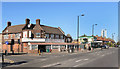
Montagu Road, Edmonton
Featuring the Enfield Food Centre on the corner of Town Road. This is along the final, rather uninspiring lower section of the Pymme's Brook Trail, an urban footpath which follows the brook from near Cockfosters down to Picketts Lock on the River Lee.
Image: © Des Blenkinsopp
Taken: 9 Oct 2018
0.05 miles
2
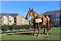
Horse on the Lawn, Montagu Road
This splendid metal horse is in front of a new crescent of houses.
I can find nothing on the web about it.
Image: © Des Blenkinsopp
Taken: 9 Oct 2018
0.09 miles
3
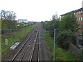
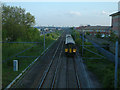
View of the railway from Picketts Lock Lane
The railway line from Stratford to Broxbourne via Waltham Cross was opened by the Northern & Eastern Railway on 15th September 1840. The next station in this (the up) direction is Angel Road although not many trains stop there. Data now shows it as the least used station in London - see https://en.wikipedia.org/wiki/Angel_Road_railway_station
Image: © Marathon
Taken: 12 Apr 2017
0.16 miles
4
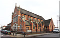
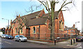
St Martin (St Demetrios), Town Road, Edmonton
Image: © John Salmon
Taken: 25 Jan 2014
0.17 miles
5
North-South Routes
The railway line from London Liverpool Street to Cambridge, together with the A1055 Meridian Way, still often called by its name when planned, the North-South Route, or simply "the new road". There is housing (mainly flats) to the west, and industry to the east. The skyscrapers of the City of London are visible on the horizon.
Image: © Stephen Dawson
Taken: 11 May 2005
0.17 miles
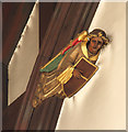
6
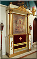
St Martin (St Demetrios), Town Road, Edmonton - Icon
Image: © John Salmon
Taken: 28 Jan 2014
0.18 miles
7
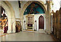
St Martin (St Demetrios), Town Road, Edmonton - Interior
Image: © John Salmon
Taken: 28 Jan 2014
0.18 miles
8
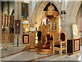
St Martin (St Demetrios), Town Road, Edmonton - Throne
Image: © John Salmon
Taken: 28 Jan 2014
0.18 miles
9
St Martin (St Demetrios), Town Road, Edmonton
Image: © John Salmon
Taken: 25 Jan 2014
0.18 miles
10
St Martin (St Demetrios), Town Road, Edmonton - Icon
Image: © John Salmon
Taken: 28 Jan 2014
0.18 miles