IMAGES TAKEN NEAR TO
Brookfield Road, LONDON, N9 0DG
Introduction
This page details the photographs taken nearby to Brookfield Road, N9 0DG by members of the Geograph project.
The Geograph project started in 2005 with the aim of publishing, organising and preserving representative images for every square kilometre of Great Britain, Ireland and the Isle of Man.

There are currently over 7.5m images from over14,400 individuals and you can help contribute to the project by visiting https://www.geograph.org.uk
Image Map
Images are licensed for reuse under creativecommons.org/licenses/by-sa/2.0
Notes
- Clicking on the map will re-center to the selected point.
- The higher the marker number, the further away the image location is from the centre of the postcode.
Image Listing (7 Images Found)
Images are licensed for reuse under creativecommons.org/licenses/by-sa/2.0
Image
Details
Distance
1
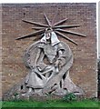
St Mary's Church Centre, Lawrence Road, London N18
Sculpture on exterior wall of St Mary's Church Centre, Lawrence Road, London N18
Image: © John Salmon
Taken: 23 Jan 2008
0.06 miles
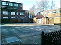
2
St Mary's Church Centre, Lawrence Road, London N18
Built 1970, architect Brian Freebourne.
Image: © John Salmon
Taken: 23 Jan 2008
0.08 miles
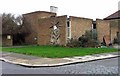
5
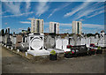
Edmonton Federation Cemetery, Upper Edmonton
Jewish cemetery founded in 1884.
Image: © Jim Osley
Taken: 11 Jun 2017
0.21 miles
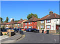
6
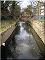
Pymme's Brook, Upper Edmonton
Taken from the footbridge from Angel Place that is parallel with Fore Street, this is in the south-west corner of the grid square. Pymme's Brook is one of the historically significant tributaries of the River Lee.
Image: © Fin Fahey
Taken: 5 Mar 2006
0.22 miles