IMAGES TAKEN NEAR TO
Christchurch Road, LONDON, N8 9QL
Introduction
This page details the photographs taken nearby to Christchurch Road, N8 9QL by members of the Geograph project.
The Geograph project started in 2005 with the aim of publishing, organising and preserving representative images for every square kilometre of Great Britain, Ireland and the Isle of Man.

There are currently over 7.5m images from over14,400 individuals and you can help contribute to the project by visiting https://www.geograph.org.uk
Image Map
Images are licensed for reuse under creativecommons.org/licenses/by-sa/2.0
Notes
- Clicking on the map will re-center to the selected point.
- The higher the marker number, the further away the image location is from the centre of the postcode.
Image Listing (318 Images Found)
Images are licensed for reuse under creativecommons.org/licenses/by-sa/2.0
Image
Details
Distance
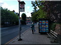
1
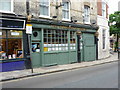
"Harringay Arms" public house, Crouch End
... defying the march of the gastro-pub!
Image: © Jim Osley
Taken: 7 Aug 2010
0.02 miles
3
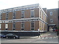
Crouch End Telephone Exchange
Situated in Crouch End Hill, this TE has the code LNCED. It provides telephone and broadband services to 21,612 residential and 1,072 non-residential premises in Crouch End, plus Highgate and Hornsey nearby. Until the late 1960s, it used to have FITzroy and MOUntview numbers. FITzroy took its name from Fitzroy Park in Highgate, whilst MOUntview was named after Mount View Road in Crouch Hill. Now it has 0208-340, 341, 347 and 348 numbers. The postcode of this TE is N8 8DH.
Image: © David Hillas
Taken: 3 Apr 2012
0.05 miles
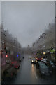
4
View over Crouch End from Crouch End Hill
Looking northeast.
Image: © Robert Lamb
Taken: 21 Sep 2019
0.06 miles
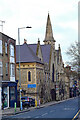
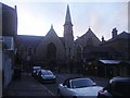
6
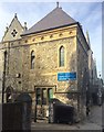
Mount Zion Cathedral, Crouch End
Extract from Crouch End Conservation Area report of 2010
Park Chapel, No. 145 Crouch Hill, currently known as the Mount Zion Cathedral,
is a large mid 19th Century local listed two storey stone church building that
extends along the back of the pavement and terminates the views along Haringey
Park. The east elevation has Gothic influences with lancet windows, gables and
tall slate roofs. The central section has a two storey projecting porch with a
parapet and a tall tower with a pointed spire. The south end has a squat tower
with a stone eaves cornice and hipped slate roof. The height, length and bulk of
the Chapel building has a somewhat overbearing effect upon this narrow part of
Crouch Hill and has a significant impact on the appearance of this part of the
conservation area.
Image: © Alan Hughes
Taken: 13 Oct 2018
0.06 miles
7
Crouch End : Park Chapel
"Park Chapel, at the foot of Crouch Hill, was opened in 1855 and registered by Congregationalists in 1856. Alterations raised its seating to 1,017 in 1877 and 1,430 by 1894. After further extensions it had 816 worshippers in the morning and 671 in the evening on one Sunday in 1903, the largest Congregationalist attendances in Hornsey. The chapel and its halls formed a popular social centre, accommodating Hornsey British school until 1877 and later being described as a 'great church'. From 1973 Baptists from Ferme Park shared Park chapel, by then a United Reformed church and still seating circa 1,400." Source: A History of the County of Middlesex: Volume 6: Friern Barnet, Finchley, Hornsey with Highgate (1980), pp. 183-189. Now partly in use as a recording studio and the Mount Zion Cathedral.
Image: © Jim Osley
Taken: 25 Dec 2020
0.07 miles
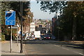
8
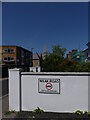
Abbots Terrace Crouch End 'Weak Road' sign
Abbots Terrace has been tarmac'ed since I took my photo of it Image] in 2018 but this is probably only a surface skim as the large sign reminds us it is a weak road. A one bedroom terrace house here will cost you over half a million pounds.
Image: © John Kingdon
Taken: 4 Jun 2023
0.07 miles
9
Park Chapel on Crouch Hill
The Cathedral of Zion currently meets around the rear entrance of the church.
Image: © David Howard
Taken: 17 Oct 2013
0.07 miles
10
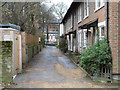
Abbotts Terrace, N8
The cottages are quite recent, the 1975/80 map denotes a 'Works' here.
Image: © Robin Webster
Taken: 22 Jan 2011
0.08 miles