IMAGES TAKEN NEAR TO
Inderwick Road, LONDON, N8 9LA
Introduction
This page details the photographs taken nearby to Inderwick Road, N8 9LA by members of the Geograph project.
The Geograph project started in 2005 with the aim of publishing, organising and preserving representative images for every square kilometre of Great Britain, Ireland and the Isle of Man.

There are currently over 7.5m images from over14,400 individuals and you can help contribute to the project by visiting https://www.geograph.org.uk
Image Map
Images are licensed for reuse under creativecommons.org/licenses/by-sa/2.0
Notes
- Clicking on the map will re-center to the selected point.
- The higher the marker number, the further away the image location is from the centre of the postcode.
Image Listing (42 Images Found)
Images are licensed for reuse under creativecommons.org/licenses/by-sa/2.0
Image
Details
Distance

5

Mini waterfalls in Stationers Park
Created in 1987, Stationers Park is one of the smaller parks in London.
Image: © Peter S
Taken: 26 Sep 2009
0.09 miles
6
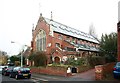
St Luke, Mayfield Road
Church now in alternative use
Image: © John Salmon
Taken: 11 Nov 2011
0.10 miles
7
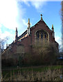
St Luke's Church, Hornsey Vale
View from Stationers Park. Built 1902-1903 to the designs of architects J.E.K. Cutts and J.P. Cutts. Converted to residential use.
Image: © Jim Osley
Taken: 27 Jan 2014
0.10 miles
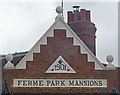
8
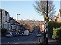
Ferne Park Road, Crouch End
Alexandra Palace in the Distance
Image: © Bikeboy
Taken: 2 Jan 2025
0.11 miles
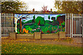
9
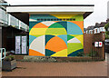
Hornsey Vale Community Centre : mural
Abstract mural by artist Jo Angell.
Image: © Jim Osley
Taken: 26 Nov 2020
0.11 miles