IMAGES TAKEN NEAR TO
Inderwick Road, LONDON, N8 9JR
Introduction
This page details the photographs taken nearby to Inderwick Road, N8 9JR by members of the Geograph project.
The Geograph project started in 2005 with the aim of publishing, organising and preserving representative images for every square kilometre of Great Britain, Ireland and the Isle of Man.

There are currently over 7.5m images from over14,400 individuals and you can help contribute to the project by visiting https://www.geograph.org.uk
Image Map
Images are licensed for reuse under creativecommons.org/licenses/by-sa/2.0
Notes
- Clicking on the map will re-center to the selected point.
- The higher the marker number, the further away the image location is from the centre of the postcode.
Image Listing (90 Images Found)
Images are licensed for reuse under creativecommons.org/licenses/by-sa/2.0
Image
Details
Distance
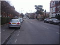
2
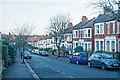
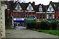
Hornsey Vale : Inderwick Road : housing terrace
Image: © Jim Osley
Taken: 24 Dec 2018
0.03 miles

6
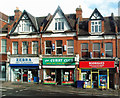
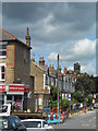
Shop fronts, Tottenham Lane, Crouch End
View from the upper deck of a W3 bus.
Image: © Jim Osley
Taken: 11 May 2016
0.09 miles
7
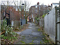
Broad Lane, N8
This promising looking byway turned out to be a dead end. The view is the way back to the main road.
Image: © Robin Webster
Taken: 22 Jan 2011
0.10 miles
8
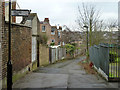
Broad Lane, N8
This promising looking byway turned out to be a dead end.
Image: © Robin Webster
Taken: 22 Jan 2011
0.10 miles
10
Ferme Park Road, Crouch End
The road crosses from N8 to N4 at the top of the hill.
Image: © David Howard
Taken: 16 Feb 2012
0.11 miles