IMAGES TAKEN NEAR TO
Briston Grove, LONDON, N8 9EX
Introduction
This page details the photographs taken nearby to Briston Grove, N8 9EX by members of the Geograph project.
The Geograph project started in 2005 with the aim of publishing, organising and preserving representative images for every square kilometre of Great Britain, Ireland and the Isle of Man.

There are currently over 7.5m images from over14,400 individuals and you can help contribute to the project by visiting https://www.geograph.org.uk
Image Map
Images are licensed for reuse under creativecommons.org/licenses/by-sa/2.0
Notes
- Clicking on the map will re-center to the selected point.
- The higher the marker number, the further away the image location is from the centre of the postcode.
Image Listing (187 Images Found)
Images are licensed for reuse under creativecommons.org/licenses/by-sa/2.0
Image
Details
Distance
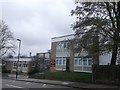
1

St Peter in Chains Primary School, Crouch End
School on the junction of Tregaron Avenue and Elm Grove (on the left).
Image: © David Anstiss
Taken: 10 Mar 2013
0.04 miles
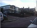
2
St Gildas Catholic Junior School, Crouch End
On Oakington Way.
Image: © David Anstiss
Taken: 10 Mar 2013
0.04 miles

4
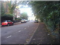
Elm Grove at the corner of Tregaron Avenue
Looking towards St Peter in Chains primary school
Image: © David Howard
Taken: 17 Oct 2013
0.05 miles
5
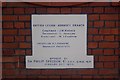
Memorial stone, former Earl Haig Memorial Hall, Crouch End (1)
One of two memorial stones of the British Legion Earl Haig Memorial Hall, Crouch End built in 1928 but recently vacated. A new use is currently being sought.
For the other stone Image
Image: © Jim Osley
Taken: 24 Dec 2010
0.07 miles
6
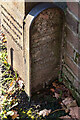
Hornsey Parish boundary marker no. 234 (1887)
On Mount View Road, Stroud Green.
Image: © Jim Osley
Taken: 19 Nov 2020
0.09 miles
7
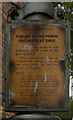
Warning to dog owners, London N8
Difficult to date this old notice. It is definitely before 1965 when the Borough of Hornsey disappeared. The town clerk, Mr Harold Bedale, a highly respected figure in local government circles, was in office for many years, certainly in the war years, and into the 1960s. I like to think that we have moved on from allowing our dogs to foul the roadways!
Image: © Jim Osley
Taken: 11 Jul 2011
0.09 miles
8

Crouch Hill
A view from the summit looking towards Crouch End and Alexandra Palace - the view is better from the front top deck of a bus at the stop in the foreground! A cyclist is cresting the climb as a W7 bus continues to struggle up behind.
Image: © Martin Addison
Taken: 28 Jan 2011
0.10 miles
9
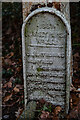
Hornsey Parish boundary marker no. 233 (1887)
On Mount View Road, Stroud Green.
Image: © Jim Osley
Taken: 19 Nov 2020
0.10 miles