IMAGES TAKEN NEAR TO
Ferme Park Road, LONDON, N8 9BN
Introduction
This page details the photographs taken nearby to Ferme Park Road, N8 9BN by members of the Geograph project.
The Geograph project started in 2005 with the aim of publishing, organising and preserving representative images for every square kilometre of Great Britain, Ireland and the Isle of Man.

There are currently over 7.5m images from over14,400 individuals and you can help contribute to the project by visiting https://www.geograph.org.uk
Image Map
Images are licensed for reuse under creativecommons.org/licenses/by-sa/2.0
Notes
- Clicking on the map will re-center to the selected point.
- The higher the marker number, the further away the image location is from the centre of the postcode.
Image Listing (104 Images Found)
Images are licensed for reuse under creativecommons.org/licenses/by-sa/2.0
Image
Details
Distance
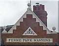
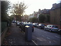
2
Ferme Park Road, Crouch End
The road crosses from N8 to N4 at the top of the hill.
Image: © David Howard
Taken: 16 Feb 2012
0.03 miles
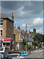
3
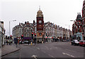
Crouch End Clocktower
The major feature of this grid square, which is mainly residential. The tower sits at a major junction in the area.
Image: © Alan Simkins
Taken: 27 Mar 2005
0.04 miles
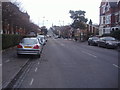
4
Ferne Park Road, Crouch End
Alexandra Palace in the Distance
Image: © Bikeboy
Taken: 2 Jan 2025
0.05 miles
6
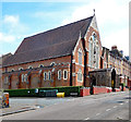
St Peter-in-Chains Roman Catholic Church, Womersley Road
Built between 1896 and 1902 to designs by priest and architect A.J.C. Scholes.
Image: © Jim Osley
Taken: 7 May 2017
0.07 miles

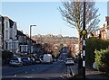
10
Hornsey Vale : Inderwick Road : housing terrace
Image: © Jim Osley
Taken: 24 Dec 2018
0.09 miles