IMAGES TAKEN NEAR TO
Cecile Park, LONDON, N8 9AS
Introduction
This page details the photographs taken nearby to Cecile Park, N8 9AS by members of the Geograph project.
The Geograph project started in 2005 with the aim of publishing, organising and preserving representative images for every square kilometre of Great Britain, Ireland and the Isle of Man.

There are currently over 7.5m images from over14,400 individuals and you can help contribute to the project by visiting https://www.geograph.org.uk
Image Map
Images are licensed for reuse under creativecommons.org/licenses/by-sa/2.0
Notes
- Clicking on the map will re-center to the selected point.
- The higher the marker number, the further away the image location is from the centre of the postcode.
Image Listing (248 Images Found)
Images are licensed for reuse under creativecommons.org/licenses/by-sa/2.0
Image
Details
Distance
1
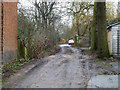
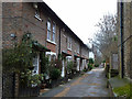
Abbotts Terrace, N8
So signed at the start of the route on Crouch Hill, where the road is surfaced and indeed has a terrace of cottages, but whether this back alley dead-end continuation still merits the name is doubtful.
Image: © Robin Webster
Taken: 22 Jan 2011
0.02 miles
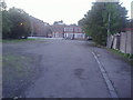
2
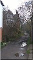
Crouch End Country Lane
Looking east down the track that bears the street name Abbots Terrace reminds one that Crouch End was until the modern era just a village in Middlesex. Those fortunate or wealthy enough to live there now regard it as an urban village with its own very hip identity.
Image: © John Kingdon
Taken: 13 Mar 2018
0.03 miles
3
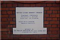
Memorial stone, former Earl Haig Memorial Hall, Crouch End (1)
One of two memorial stones of the British Legion Earl Haig Memorial Hall, Crouch End built in 1928 but recently vacated. A new use is currently being sought.
For the other stone Image
Image: © Jim Osley
Taken: 24 Dec 2010
0.04 miles
4
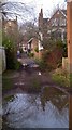
Abbots Terrace Crouch End
Unadopted road looking towards Crouch Hill giving off a feeling of abandonment
Image: © John Kingdon
Taken: 13 Mar 2018
0.06 miles
5
Cottages, Abbotts Terrace, N8
Quite recent, the 1975/80 map denotes a 'Works' here.
Image: © Robin Webster
Taken: 22 Jan 2011
0.07 miles
7
Abbotts Terrace, N8
The cottages are quite recent, the 1975/80 map denotes a 'Works' here.
Image: © Robin Webster
Taken: 22 Jan 2011
0.08 miles
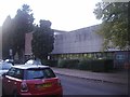
8
The rear of Hornsey Town Hall
Although up for redevelopment in 2007-2013 the entire complex appears now to be abandoned.
Image: © David Howard
Taken: 17 Oct 2013
0.08 miles
9

Hornsey Library 2024
The utilitarian grace of the 1960's Hornsey Library matches well the 1930's Town Hall tower, looking like a secular bell tower, behind it. Although the library was recently refurbished the roof now requires work and inside the windows one can just see the internal scaffolding put up for this purpose. The library remains open during this work and is a go to place for students.
Image: © John Kingdon
Taken: 5 Nov 2024
0.09 miles
10
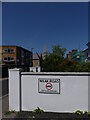
Abbots Terrace Crouch End 'Weak Road' sign
Abbots Terrace has been tarmac'ed since I took my photo of it Image] in 2018 but this is probably only a surface skim as the large sign reminds us it is a weak road. A one bedroom terrace house here will cost you over half a million pounds.
Image: © John Kingdon
Taken: 4 Jun 2023
0.09 miles