IMAGES TAKEN NEAR TO
Dashwood Road, LONDON, N8 9AD
Introduction
This page details the photographs taken nearby to Dashwood Road, N8 9AD by members of the Geograph project.
The Geograph project started in 2005 with the aim of publishing, organising and preserving representative images for every square kilometre of Great Britain, Ireland and the Isle of Man.

There are currently over 7.5m images from over14,400 individuals and you can help contribute to the project by visiting https://www.geograph.org.uk
Image Map
Images are licensed for reuse under creativecommons.org/licenses/by-sa/2.0
Notes
- Clicking on the map will re-center to the selected point.
- The higher the marker number, the further away the image location is from the centre of the postcode.
Image Listing (76 Images Found)
Images are licensed for reuse under creativecommons.org/licenses/by-sa/2.0
Image
Details
Distance
2
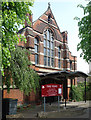
Holy Trinity Church, Stroud Green
The building was, in fact, built as the church hall for an adjacent church which was suffered bomb damage in 1944 and finally demolished in 1960. The church hall, built in 1913 to a design by architect J.S. Alder, was dedicated for church use in 1961.
Image: © Jim Osley
Taken: 7 May 2017
0.04 miles
3
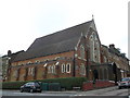
St Peter in Chains Church, Stroud Green
Roman Catholic Church on the junction of Dashwood Road and Womersley Road (on the right).
Image: © David Anstiss
Taken: 10 Mar 2013
0.04 miles
4
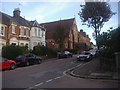
Womersley Road, Crouch End
Looking towards St Peter in Chains church.
Image: © David Howard
Taken: 17 Oct 2013
0.07 miles
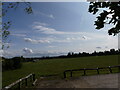
5
View over Crouch End Reservoirs
Looking from Mount View Road over the covered water reservoirs towards central London.
Image: © David Anstiss
Taken: 10 Mar 2013
0.08 miles
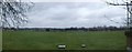
6
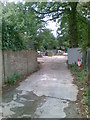
Crouch Hill Covered Reservoir
The grassy field below an expansive sky is actually the roof of the covered reservoir. To the left is a hatchway into the reservoir and in the far distance the tall buildings of Canary Wharf.
Image: © John Kingdon
Taken: 26 Sep 2023
0.09 miles
7
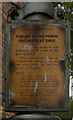
Warning to dog owners, London N8
Difficult to date this old notice. It is definitely before 1965 when the Borough of Hornsey disappeared. The town clerk, Mr Harold Bedale, a highly respected figure in local government circles, was in office for many years, certainly in the war years, and into the 1960s. I like to think that we have moved on from allowing our dogs to foul the roadways!
Image: © Jim Osley
Taken: 11 Jul 2011
0.10 miles
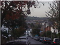
10
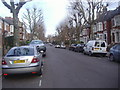
Mountview Road, Stroud Green
The road is in N4 which is centred on Finsbury Park but still in the London borough of Haringey. The majority of N4 is in Islington which begins just beyond the end of the road.
Image: © David Howard
Taken: 16 Feb 2012
0.12 miles