IMAGES TAKEN NEAR TO
The Grove, Lynton Road, LONDON, N8 8ST
Introduction
This page details the photographs taken nearby to The Grove, Lynton Road, N8 8ST by members of the Geograph project.
The Geograph project started in 2005 with the aim of publishing, organising and preserving representative images for every square kilometre of Great Britain, Ireland and the Isle of Man.

There are currently over 7.5m images from over14,400 individuals and you can help contribute to the project by visiting https://www.geograph.org.uk
Image Map
Images are licensed for reuse under creativecommons.org/licenses/by-sa/2.0
Notes
- Clicking on the map will re-center to the selected point.
- The higher the marker number, the further away the image location is from the centre of the postcode.
Image Listing (189 Images Found)
Images are licensed for reuse under creativecommons.org/licenses/by-sa/2.0
Image
Details
Distance
1
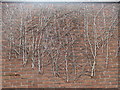
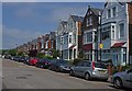
The Grove Crouch End Unintentional Art
Wall on the west side of the road where the bleached branches of a climber have created their own art installation.
Image: © John Kingdon
Taken: 18 Mar 2017
0.01 miles
3
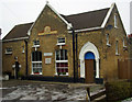
Former Congregationalist Mission Hall, The Grove, Crouch End (1881)
Converted to domestic use.
Image: © Jim Osley
Taken: 27 Dec 2010
0.04 miles
4
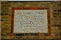
Foundation stone, former Grove Mission Hall, Crouch End
Image: © Jim Osley
Taken: 27 Dec 2010
0.04 miles
5
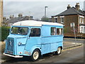
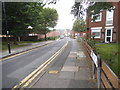
Lynton Road Crouch End
There are two of these Citroen vans each within half a mile of the centre of Crouch End. The UK number plate in the French style suggests it's a late 1960's model.
Image: © John Kingdon
Taken: 18 Mar 2017
0.05 miles
7
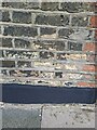
38 Palace Road Benchmark
Just about visible.
Image: © Cipollini
Taken: 11 Jul 2024
0.05 miles
9
Patterned brickwork, Maynard Arms, Crouch End
Image: © Jim Osley
Taken: 12 Jun 2018
0.05 miles
10
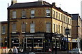
The Maynard, Park Road N8
Park Road was once known as Maynard Street.
Image: © Pierre Terre
Taken: 12 Nov 2006
0.06 miles