IMAGES TAKEN NEAR TO
Barrington Road, LONDON, N8 8QS
Introduction
This page details the photographs taken nearby to Barrington Road, N8 8QS by members of the Geograph project.
The Geograph project started in 2005 with the aim of publishing, organising and preserving representative images for every square kilometre of Great Britain, Ireland and the Isle of Man.

There are currently over 7.5m images from over14,400 individuals and you can help contribute to the project by visiting https://www.geograph.org.uk
Image Map
Images are licensed for reuse under creativecommons.org/licenses/by-sa/2.0
Notes
- Clicking on the map will re-center to the selected point.
- The higher the marker number, the further away the image location is from the centre of the postcode.
Image Listing (142 Images Found)
Images are licensed for reuse under creativecommons.org/licenses/by-sa/2.0
Image
Details
Distance
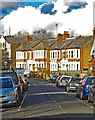
1
Solar panelled roofs, Barrington Road
View from Priory Park.
Image: © Jim Osley
Taken: 23 Nov 2013
0.01 miles
2
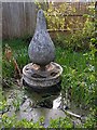
"The Drop" water feature, Priory Park
Sculpture by Marilyn Collins, commissioned by the Friends of Priory Park, 2000
Image: © Jim Osley
Taken: 17 Apr 2012
0.03 miles
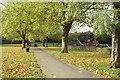
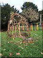
3
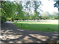
Priory Park looking towards the playground
Image: © David Howard
Taken: 11 Jul 2013
0.04 miles
7
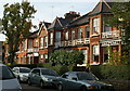
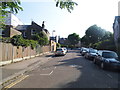
Carysfort Road, N8
Typical of housing built in this area in the 1890s, now in use as a mixture of family houses and flats.
Image: © Pierre Terre
Taken: 12 Nov 2006
0.06 miles