IMAGES TAKEN NEAR TO
Chestnut Avenue, LONDON, N8 8NY
Introduction
This page details the photographs taken nearby to Chestnut Avenue, N8 8NY by members of the Geograph project.
The Geograph project started in 2005 with the aim of publishing, organising and preserving representative images for every square kilometre of Great Britain, Ireland and the Isle of Man.

There are currently over 7.5m images from over14,400 individuals and you can help contribute to the project by visiting https://www.geograph.org.uk
Image Map
Images are licensed for reuse under creativecommons.org/licenses/by-sa/2.0
Notes
- Clicking on the map will re-center to the selected point.
- The higher the marker number, the further away the image location is from the centre of the postcode.
Image Listing (176 Images Found)
Images are licensed for reuse under creativecommons.org/licenses/by-sa/2.0
Image
Details
Distance
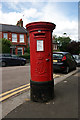
1
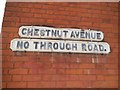
No through road sign
These were made roughly before 1964 in this style, although the one line versions were made by local councils, often copying their local font, rather than the three line standardised versions issued nationally.
Image: © David Howard
Taken: 19 Aug 2014
0.02 miles
3
Rokesely Avenue at the junction of Middle Lane
Image: © David Howard
Taken: 19 Aug 2014
0.05 miles
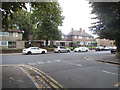
4
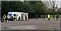
Hornsey : COVID-19 mobile testing station, Priory Park
Image: © Jim Osley
Taken: 20 Dec 2021
0.05 miles
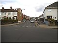
5
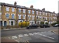
Terrace of houses on Palace Road, Crouch End
Image: © David Howard
Taken: 19 Aug 2014
0.06 miles
7
Middle Lane at the junction of Palace Road
Image: © David Howard
Taken: 19 Aug 2014
0.07 miles
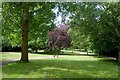
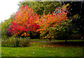
10
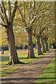
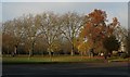
Hornsey : London Plane trees, Priory Park
Image: © Jim Osley
Taken: 31 Oct 2018
0.08 miles