IMAGES TAKEN NEAR TO
Priory Road, LONDON, N8 8LH
Introduction
This page details the photographs taken nearby to Priory Road, N8 8LH by members of the Geograph project.
The Geograph project started in 2005 with the aim of publishing, organising and preserving representative images for every square kilometre of Great Britain, Ireland and the Isle of Man.

There are currently over 7.5m images from over14,400 individuals and you can help contribute to the project by visiting https://www.geograph.org.uk
Image Map
Images are licensed for reuse under creativecommons.org/licenses/by-sa/2.0
Notes
- Clicking on the map will re-center to the selected point.
- The higher the marker number, the further away the image location is from the centre of the postcode.
Image Listing (133 Images Found)
Images are licensed for reuse under creativecommons.org/licenses/by-sa/2.0
Image
Details
Distance
1
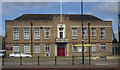
Territorial Army (TA) Centre, Hornsey, London N8
Image: © Jim Osley
Taken: 14 Mar 2010
0.01 miles

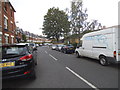
3
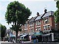
Priory Road / Nightingale Lane, N8
The north side, west of Nightingale Lane.
The original course of the New River ran along the southern side of Hornsey High Street from Nightingale Lane - see Image
Image: © Mike Quinn
Taken: 15 Jul 2015
0.02 miles

7
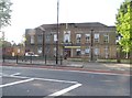
The Territorial Army building on Priory Road, Hornsey
Image: © David Howard
Taken: 11 Jul 2013
0.04 miles
9
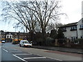
Priory Road, Hornsey
Looking towards Middle Lane
Image: © David Howard
Taken: 5 Feb 2014
0.05 miles