IMAGES TAKEN NEAR TO
Topsfield Close, LONDON, N8 8DW
Introduction
This page details the photographs taken nearby to Topsfield Close, N8 8DW by members of the Geograph project.
The Geograph project started in 2005 with the aim of publishing, organising and preserving representative images for every square kilometre of Great Britain, Ireland and the Isle of Man.

There are currently over 7.5m images from over14,400 individuals and you can help contribute to the project by visiting https://www.geograph.org.uk
Image Map
Images are licensed for reuse under creativecommons.org/licenses/by-sa/2.0
Notes
- Clicking on the map will re-center to the selected point.
- The higher the marker number, the further away the image location is from the centre of the postcode.
Image Listing (177 Images Found)
Images are licensed for reuse under creativecommons.org/licenses/by-sa/2.0
Image
Details
Distance
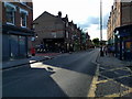
2
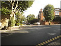
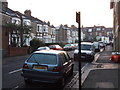
Wolseley Road at the junction of Berkeley Road
Image: © David Howard
Taken: 19 Aug 2014
0.04 miles
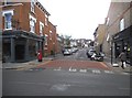
3
Park Road from the end of Wolseley Road
Image: © David Howard
Taken: 28 Sep 2021
0.04 miles
4
Shanklin Road at the junction of Park Road
Image: © David Howard
Taken: 19 Aug 2014
0.05 miles
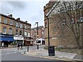
6
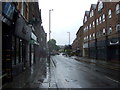
Park Road, Crouch End
The A1201 on a damp day.
Image: © JThomas
Taken: 27 Jul 2019
0.05 miles
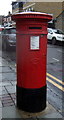
8
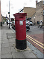
Victorian Pillar Box, Shanklin RoadCrouch End, London N8
Image: © Christine Matthews
Taken: 4 May 2015
0.06 miles
10
Victorian postbox on Park Road, Crouch End
Postbox No. N8 22.
Image: © JThomas
Taken: 27 Jul 2019
0.07 miles