IMAGES TAKEN NEAR TO
Birkbeck Road, LONDON, N8 7SR
Introduction
This page details the photographs taken nearby to Birkbeck Road, N8 7SR by members of the Geograph project.
The Geograph project started in 2005 with the aim of publishing, organising and preserving representative images for every square kilometre of Great Britain, Ireland and the Isle of Man.

There are currently over 7.5m images from over14,400 individuals and you can help contribute to the project by visiting https://www.geograph.org.uk
Image Map
Images are licensed for reuse under creativecommons.org/licenses/by-sa/2.0
Notes
- Clicking on the map will re-center to the selected point.
- The higher the marker number, the further away the image location is from the centre of the postcode.
Image Listing (169 Images Found)
Images are licensed for reuse under creativecommons.org/licenses/by-sa/2.0
Image
Details
Distance
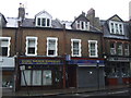
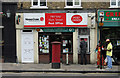
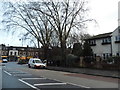
2
Middle Lane, N8
Just south of its junction with Hornsey High Street.
Image: © Mike Quinn
Taken: 15 Jul 2015
0.02 miles
4
Junction of Middle Lane / Priory Road (A504), Hornsey
Image: © JThomas
Taken: 27 Jul 2019
0.03 miles
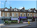
6
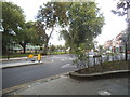
Park Road at the junction of Middle Lane
Image: © David Howard
Taken: 19 Aug 2014
0.04 miles

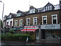
8
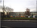
St Mary's primary school, Hornsey High Street
Image: © David Howard
Taken: 20 Jan 2016
0.05 miles
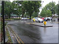
10
Priory Road, Hornsey
Looking towards Middle Lane
Image: © David Howard
Taken: 5 Feb 2014
0.05 miles