IMAGES TAKEN NEAR TO
Rectory Gardens, LONDON, N8 7PJ
Introduction
This page details the photographs taken nearby to Rectory Gardens, N8 7PJ by members of the Geograph project.
The Geograph project started in 2005 with the aim of publishing, organising and preserving representative images for every square kilometre of Great Britain, Ireland and the Isle of Man.

There are currently over 7.5m images from over14,400 individuals and you can help contribute to the project by visiting https://www.geograph.org.uk
Image Map
Images are licensed for reuse under creativecommons.org/licenses/by-sa/2.0
Notes
- Clicking on the map will re-center to the selected point.
- The higher the marker number, the further away the image location is from the centre of the postcode.
Image Listing (140 Images Found)
Images are licensed for reuse under creativecommons.org/licenses/by-sa/2.0
Image
Details
Distance
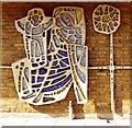
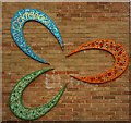
3
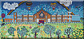
Hornsey : mosaic panel, St Mary's School
Featuring Alexandra Park and Palace.
Image: © Jim Osley
Taken: 30 Dec 2018
0.05 miles
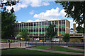
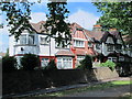
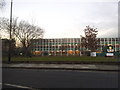
6
St Mary's Junior School, Hornsey, London N8
Image: © Jim Osley
Taken: 19 Feb 2010
0.06 miles
7
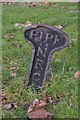
New River waymarker, Avenue Gardens, London N22
The New River's course from Hertfordshire to London is piped underground in this area. NRC stands for New River Company
Image: © Jim Osley
Taken: 19 Feb 2010
0.06 miles
9
Mosaic, Camspace Youth Centre, Hornsey
Created by Julie Beech and Norma Vendee with local children.
Image: © Jim Osley
Taken: 6 Feb 2011
0.07 miles
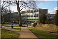
10
St Mary's primary school, Hornsey High Street
Image: © David Howard
Taken: 20 Jan 2016
0.07 miles