IMAGES TAKEN NEAR TO
High Street, LONDON, N8 7NX

Introduction

This page details the photographs taken nearby to High Street, N8 7NX by members of the Geograph project.

The Geograph project started in 2005 with the aim of publishing, organising and preserving representative images for every square kilometre of Great Britain, Ireland and the Isle of Man.

There are currently over 7.5m images from over14,400 individuals and you can help contribute to the project by visiting https://www.geograph.org.uk

Image Map


Images are licensed for reuse under creativecommons.org/licenses/by-sa/2.0
Notes
  • Clicking on the map will re-center to the selected point.
  • The higher the marker number, the further away the image location is from the centre of the postcode.

Image Listing (184 Images Found)

Images are licensed for reuse under creativecommons.org/licenses/by-sa/2.0
  • ...
Image
Details
Distance
1
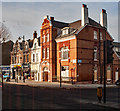
Hornsey High Street, N8 (3)
The north side, between Campsbourne Road and The Campsbourne. The original course of the New River ran eastwards along the southern side of Hornsey High Street from Nightingale Lane - see Image
Image: © Mike Quinn Taken: 15 Jul 2015
0.01 miles
2
Christian epigram, Campsbourne Baptist Church
Image: © Jim Osley Taken: 20 Jun 2013
0.03 miles
3
Topical Christian message, Hornsey
As the football season gets underway a message from Campsbourne Baptist Church!
Image: © Jim Osley Taken: 13 Aug 2014
0.03 miles
4
Hornsey High Street, N8 (2)
The north side, between Myddelton Road and Campsbourne Road. The original course of the New River ran eastwards along the southern side of Hornsey High Street from Nightingale Lane - see Image
Image: © Mike Quinn Taken: 15 Jul 2015
0.03 miles
5
Campsbourne Baptist Church, The Campsbourne, N8
Image: © Mike Quinn Taken: 15 Jul 2015
0.04 miles
6
Mary Louise Dry Cleaners 7 High Street Hornsey N8
The shopfront signage states that the dry cleaning business was established in 1969 and the condition of the paintwork and lettering do not suggest recent gentrification. Moreover, the dry cleaning business is still in operation. The telephone number gives the area code as 0208 and this only came into being in the year 2000 so probably the signage is from shortly after that.
Image: © John Kingdon Taken: 5 Nov 2024
0.04 miles
7
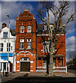
Hornsey National Hall, 31 Hornsey High Street, London. N8
The former Hornsey National Hall, or Hornsey Parish Hall, was built to the designs of architect John Farrer in 1888. The building is currently in use as a function hall. Farrer was responsible for many of the buildings in this area, and a road nearby is named after him.
Image: © Jim Osley Taken: 1 Mar 2007
0.04 miles
8
The Campsbourne, N8
Image: © Mike Quinn Taken: 15 Jul 2015
0.04 miles
9
Hornsey High Street
Image: © Jim Osley Taken: 5 Dec 2016
0.04 miles
10
Former National Hall, Hornsey High Street
The National Hall and short terrace to the left were all built to the designs of local architect John Farrer. The National Hall is currently home to the Hornsey Diyanet Camii mosque.
Image: © Jim Osley Taken: 5 Dec 2016
0.04 miles
  • ...