IMAGES TAKEN NEAR TO
Great Amwell Lane, LONDON, N8 7NH
Introduction
This page details the photographs taken nearby to Great Amwell Lane, N8 7NH by members of the Geograph project.
The Geograph project started in 2005 with the aim of publishing, organising and preserving representative images for every square kilometre of Great Britain, Ireland and the Isle of Man.

There are currently over 7.5m images from over14,400 individuals and you can help contribute to the project by visiting https://www.geograph.org.uk
Image Map
Images are licensed for reuse under creativecommons.org/licenses/by-sa/2.0
Notes
- Clicking on the map will re-center to the selected point.
- The higher the marker number, the further away the image location is from the centre of the postcode.
Image Listing (235 Images Found)
Images are licensed for reuse under creativecommons.org/licenses/by-sa/2.0
Image
Details
Distance
1
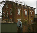
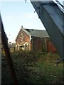
Former Campsbourne Well Pumping Station (1887), Cross Lane, Hornsey
One of a number of pumping stations located near the New River.
Image: © Jim Osley
Taken: 9 Mar 2010
0.01 miles
2
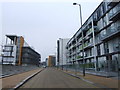
New development on Chadwell Lane, Hornsey
Image: © Chris Whippet
Taken: 31 Dec 2008
0.02 miles

4
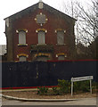
Former Campsbourne Well Pumping Station (1887), Cross Lane, Hornsey
Image: © Jim Osley
Taken: 9 Mar 2010
0.03 miles
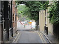
5

New River Village housing development, Hornsey
Image: © Jim Osley
Taken: 30 May 2011
0.03 miles


10
Former Campsbourne Well pumping station building, Hornsey
Image: © Jim Osley
Taken: 31 Jan 2011
0.05 miles