IMAGES TAKEN NEAR TO
High Street, LONDON, N8 7FE
Introduction
This page details the photographs taken nearby to High Street, N8 7FE by members of the Geograph project.
The Geograph project started in 2005 with the aim of publishing, organising and preserving representative images for every square kilometre of Great Britain, Ireland and the Isle of Man.

There are currently over 7.5m images from over14,400 individuals and you can help contribute to the project by visiting https://www.geograph.org.uk
Image Map
Images are licensed for reuse under creativecommons.org/licenses/by-sa/2.0
Notes
- Clicking on the map will re-center to the selected point.
- The higher the marker number, the further away the image location is from the centre of the postcode.
Image Listing (226 Images Found)
Images are licensed for reuse under creativecommons.org/licenses/by-sa/2.0
Image
Details
Distance
1
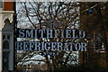
Smithfield Refrigerator Works sign, Cross Lane, Hornsey
Image: © Jim Osley
Taken: 11 Mar 2007
0.01 miles
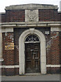
2
Hornsey Borough Council Building Remnant
This structure which bears the Arms of Hornsey Borough Council is all that remains of the 1930's Hornsey Public Baths and Washhouse demolished for the new housing and Sainsbury's store development. This small remnant was taken down and rebuilt in this position and seems now to house an electricity transformer. The Arms bears the inscription Fortior Quo Paratior, Latin for the better prepared, the stronger.
The building stands in the lowest point in the immediate area and is where once the New River flowed as it followed the contours of the landscape until the 1850's when it was rerouted alongside the new railway that is now the east coast mainline.
Image: © John Kingdon
Taken: 1 Aug 2024
0.02 miles
3
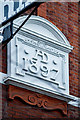
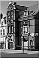
Hornsey : Great Northern Tavern : date plaque
Full view of building and notes at this https://www.geograph.org.uk/photo/5150260.
Image: © Jim Osley
Taken: 30 Dec 2018
0.02 miles
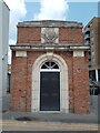
4
Former public baths and wash house, Hornsey, London N8
View of neo-Georgian entrance, with coat of arms of the old Borough of Hornsey above.
Image: © Jim Osley
Taken: 9 Mar 2010
0.03 miles
5
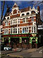
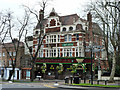
Great Northern Railway Tavern, Hornsey High Street
Built in 1897, to the designs of architects Shoebridge & Rising.
Image: © Jim Osley
Taken: 2 Mar 2007
0.03 miles
6
Entrance, Campsbourne Well Pumping Station (1887)
View through a gap in the hoarding surrounding this Victorian structure.
Image: © Jim Osley
Taken: 1 Feb 2013
0.03 miles
7
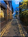
Cross Lane alongside the Great Northern Railway Tavern
Image: © Tom Page
Taken: 3 Nov 2021
0.03 miles
8
The Great Northern Railway Tavern, Hornsey N8
A grade II listed building from about 1900. To the right is Cross Lane, with the name of one of its once major addresses over the entrance. The Smithfield Refrigerator Works was on a site to the west of the lane which is now redeveloped as flats. Little seems to be available about the activities of the company, and when it closed down here is uncertain, possibly the 1960s - the large premises were mapped as a warehouse by the 1970s/80s. It produced commercial refrigerators (at least) under the name Smithfridge.
Image: © Robin Webster
Taken: 22 Jan 2011
0.04 miles
9
Hornsey : former National Hall
Dates from 1888 : built to the designs of architect John Farrer. Currenty a mosque.
Image: © Jim Osley
Taken: 4 May 2019
0.04 miles
10
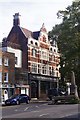
"The Great Northern Railway Tavern", Hornsey
Grade II listed public house of the 1890s, built to the designs of architects Shoebridge & Rising: architectural description at this https://historicengland.org.uk/listing/the-list/list-entry/1079213
Image: © Jim Osley
Taken: 10 Oct 2016
0.04 miles