IMAGES TAKEN NEAR TO
Hillfield Avenue, LONDON, N8 7DU
Introduction
This page details the photographs taken nearby to Hillfield Avenue, N8 7DU by members of the Geograph project.
The Geograph project started in 2005 with the aim of publishing, organising and preserving representative images for every square kilometre of Great Britain, Ireland and the Isle of Man.

There are currently over 7.5m images from over14,400 individuals and you can help contribute to the project by visiting https://www.geograph.org.uk
Image Map
Images are licensed for reuse under creativecommons.org/licenses/by-sa/2.0
Notes
- Clicking on the map will re-center to the selected point.
- The higher the marker number, the further away the image location is from the centre of the postcode.
Image Listing (223 Images Found)
Images are licensed for reuse under creativecommons.org/licenses/by-sa/2.0
Image
Details
Distance
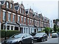
2
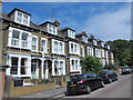
Hillfield Avenue / Temple Road, N8
Shows the location of Image
Image: © Mike Quinn
Taken: 15 Jul 2015
0.02 miles
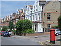
3
"Three Compasses" public house. Hornsey (1896)
Image: © Jim Osley
Taken: 11 Aug 2013
0.03 miles
4
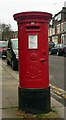
Edward VII postbox, Hillfield Avenue, Hornsey
Image: © Jim Osley
Taken: 24 Jan 2011
0.03 miles
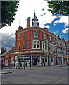
5
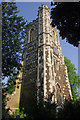
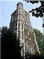
St Mary's Church Tower, Hornsey
Most of St. Mary's Church was demolished in 1927 leaving only the tower.
Image: © Stephen McKay
Taken: 6 Jun 2013
0.03 miles
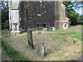
8

Gravestones at the foot of St. Mary's Tower, Hornsey (2)
See Image
Image: © Mike Quinn
Taken: 18 Jun 2015
0.04 miles
9
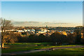
View over Hornsey and beyond from Alexandra Palace
Image: © Jim Osley
Taken: 28 Nov 2016
0.04 miles
10
Gravestones at the foot of St. Mary's Tower, Hornsey
See Image
Image: © Mike Quinn
Taken: 18 Jun 2015
0.04 miles