IMAGES TAKEN NEAR TO
Boyton Road, LONDON, N8 7AU
Introduction
This page details the photographs taken nearby to Boyton Road, N8 7AU by members of the Geograph project.
The Geograph project started in 2005 with the aim of publishing, organising and preserving representative images for every square kilometre of Great Britain, Ireland and the Isle of Man.

There are currently over 7.5m images from over14,400 individuals and you can help contribute to the project by visiting https://www.geograph.org.uk
Image Map
Images are licensed for reuse under creativecommons.org/licenses/by-sa/2.0
Notes
- Clicking on the map will re-center to the selected point.
- The higher the marker number, the further away the image location is from the centre of the postcode.
Image Listing (130 Images Found)
Images are licensed for reuse under creativecommons.org/licenses/by-sa/2.0
Image
Details
Distance
1
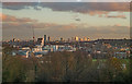
View of Hornsey and beyond from Alexandra Palace
Image: © Jim Osley
Taken: 30 Nov 2018
0.04 miles
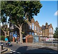
4
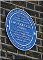
Hornsey : Emma Clarke plaque
For more on the life and times of pioneering black British female footballer see this https://thesefootballtimes.co/2019/02/12/the-triumph-and-the-tragedy-of-emma-clarke-britains-first-black-female-footballer/.
Image: © Jim Osley
Taken: 11 Nov 2020
0.07 miles

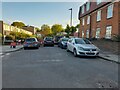
6
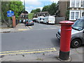
Nightingale Lane / Eastfield Road, N8
Shows the location of Image
Image: © Mike Quinn
Taken: 15 Jul 2015
0.08 miles
8
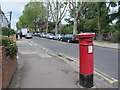
Nightingale Lane / Hawthorn Road, N8
Shows the location of Image
Image: © Mike Quinn
Taken: 15 Jul 2015
0.08 miles
10
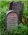
Hornsey Parish boundary marker no. 435 (1887)
Image: © Jim Osley
Taken: 11 Nov 2020
0.09 miles