IMAGES TAKEN NEAR TO
Campsfield Road, LONDON, N8 7AL
Introduction
This page details the photographs taken nearby to Campsfield Road, N8 7AL by members of the Geograph project.
The Geograph project started in 2005 with the aim of publishing, organising and preserving representative images for every square kilometre of Great Britain, Ireland and the Isle of Man.

There are currently over 7.5m images from over14,400 individuals and you can help contribute to the project by visiting https://www.geograph.org.uk
Image Map (Loading...)


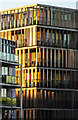
Getting Data...Please wait
Leaflet Map data © OpenStreetMap
Images are licensed for reuse under creativecommons.org/licenses/by-sa/2.0
Notes
- Clicking on the map will re-center to the selected point.
- The higher the marker number, the further away the image location is from the centre of the postcode.
Image Listing (133 Images Found)
Images are licensed for reuse under creativecommons.org/licenses/by-sa/2.0
Image
Details
Distance
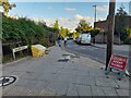
4
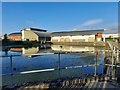
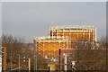
Tank at Hornsey Water Treatment Works
This tank just off Newlands Rd is probably a settling tank or filter tank.
Image: © Nigel Mykura
Taken: 23 Aug 2015
0.06 miles
5
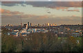
View of Hornsey and beyond from Alexandra Palace
Image: © Jim Osley
Taken: 30 Nov 2018
0.06 miles
6
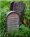
Hornsey Parish boundary marker no. 435 (1887)
Image: © Jim Osley
Taken: 11 Nov 2020
0.07 miles
7
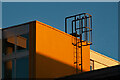
Hornsey : access ladder, New River Village
Image: © Jim Osley
Taken: 27 Jan 2022
0.08 miles
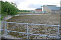
8
Hornsey Reservoir
This is the small extra pool
Image: © David Howard
Taken: 26 Sep 2021
0.08 miles
10
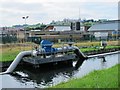
Waterworks by the New River (2)
Looking WNW towards Alexandra Palace. See also Image
Image: © Mike Quinn
Taken: 15 Jul 2015
0.09 miles