IMAGES TAKEN NEAR TO
Wightman Road, LONDON, N8 0LT
Introduction
This page details the photographs taken nearby to Wightman Road, N8 0LT by members of the Geograph project.
The Geograph project started in 2005 with the aim of publishing, organising and preserving representative images for every square kilometre of Great Britain, Ireland and the Isle of Man.

There are currently over 7.5m images from over14,400 individuals and you can help contribute to the project by visiting https://www.geograph.org.uk
Image Map
Images are licensed for reuse under creativecommons.org/licenses/by-sa/2.0
Notes
- Clicking on the map will re-center to the selected point.
- The higher the marker number, the further away the image location is from the centre of the postcode.
Image Listing (245 Images Found)
Images are licensed for reuse under creativecommons.org/licenses/by-sa/2.0
Image
Details
Distance
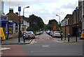
3
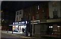
Road works on Wightman Road, Harringay
Image: © David Howard
Taken: 26 Jan 2022
0.01 miles
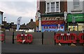
7
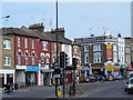
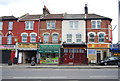
Shops on Wightman Road, Hornsey
The shops begin here, extend along Turnpike Lane to Wood Green and past the station on Wood Green High Road around a mile away.
Image: © David Howard
Taken: 2 Oct 2014
0.03 miles
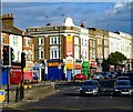
10
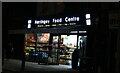
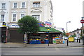
Harringay Food Centre on Wightman Road, Harringay
Image: © David Howard
Taken: 28 Aug 2022
0.03 miles